IMAGES TAKEN NEAR TO
Lamplugh, WORKINGTON, CA14 4SF
Introduction
This page details the photographs taken nearby to CA14 4SF by members of the Geograph project.
The Geograph project started in 2005 with the aim of publishing, organising and preserving representative images for every square kilometre of Great Britain, Ireland and the Isle of Man.

There are currently over 7.5m images from over14,400 individuals and you can help contribute to the project by visiting https://www.geograph.org.uk
Image Map
Images are licensed for reuse under creativecommons.org/licenses/by-sa/2.0
Notes
- Clicking on the map will re-center to the selected point.
- The higher the marker number, the further away the image location is from the centre of the postcode.
Image Listing (5 Images Found)
Images are licensed for reuse under creativecommons.org/licenses/by-sa/2.0
Image
Details
Distance
2
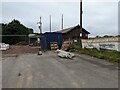
The new Lamplugh Village Hall
Work in progress!
Image: © David Medcalf
Taken: 6 Jul 2022
0.11 miles
3
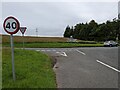
Kirkland turnoff from A5086.
Usually a bad thing to have a junction on a corner but this one has good visibility.
Image: © John Holmes
Taken: 10 Dec 2005
0.14 miles
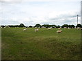
4
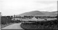
Fells near Lamplugh
NE view from A5086 near Murton, to Owsen Fell; Lamplugh Church just visible centre left.
Image: © Ben Brooksbank
Taken: 25 Sep 1961
0.16 miles