IMAGES TAKEN NEAR TO
Cinder Hill, WORKINGTON, CA14 1YU
Introduction
This page details the photographs taken nearby to Cinder Hill, CA14 1YU by members of the Geograph project.
The Geograph project started in 2005 with the aim of publishing, organising and preserving representative images for every square kilometre of Great Britain, Ireland and the Isle of Man.

There are currently over 7.5m images from over14,400 individuals and you can help contribute to the project by visiting https://www.geograph.org.uk
Image Map
Images are licensed for reuse under creativecommons.org/licenses/by-sa/2.0
Notes
- Clicking on the map will re-center to the selected point.
- The higher the marker number, the further away the image location is from the centre of the postcode.
Image Listing (4 Images Found)
Images are licensed for reuse under creativecommons.org/licenses/by-sa/2.0
Image
Details
Distance
1
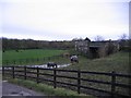
Railway bridge
The railway is lon gone and the river bridge is in the background.
Image: © John Holmes
Taken: 14 Nov 2005
0.06 miles
2
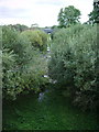
Dismantled railway
Part of the Bridgefoot to Branthwaite Railway
Image: © Alexander P Kapp
Taken: 25 Sep 2007
0.09 miles
3
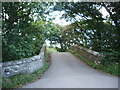
Road bridge
Carries the Dean to Little Clifton road over the River Marron on the south side of Little Clifton
Image: © Alexander P Kapp
Taken: 25 Sep 2007
0.11 miles
4
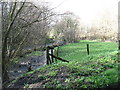
Curl Beck, looking downstream
In less than 200 metres Curl Beck flows into the River Marron and thence north into the River Derwent.
Image: © David Purchase
Taken: 20 Mar 2017
0.16 miles