IMAGES TAKEN NEAR TO
Greengarth, WORKINGTON, CA14 1TQ
Introduction
This page details the photographs taken nearby to Greengarth, CA14 1TQ by members of the Geograph project.
The Geograph project started in 2005 with the aim of publishing, organising and preserving representative images for every square kilometre of Great Britain, Ireland and the Isle of Man.

There are currently over 7.5m images from over14,400 individuals and you can help contribute to the project by visiting https://www.geograph.org.uk
Image Map
Images are licensed for reuse under creativecommons.org/licenses/by-sa/2.0
Notes
- Clicking on the map will re-center to the selected point.
- The higher the marker number, the further away the image location is from the centre of the postcode.
Image Listing (8 Images Found)
Images are licensed for reuse under creativecommons.org/licenses/by-sa/2.0
Image
Details
Distance
1
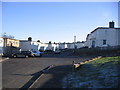
Post war housing at Great Clifton
Built as cheap temporary housing. Some have been knocked down to make the estate smaller.
Image: © John Holmes
Taken: 18 Nov 2005
0.06 miles
2
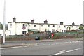
Village Phone and Post Box
The telephone kiosk and post box for Great Clifton are sited next to each other on the A66. They are at the West end of the village at a road junction.
Image: © J P Simpson
Taken: 30 Aug 2008
0.08 miles
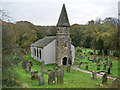
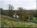
3

Camerton Church
Beautifully sited in an oxbow of the River Derwent, this well-maintained church and graveyard is nearly a kilometre from the village.
Image: © Bob Jenkins
Taken: 24 May 2006
0.23 miles
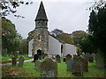
4
Parish Church of St Peter, Camerton
Image: © Alexander P Kapp
Taken: 24 Oct 2007
0.23 miles
5
Parish Church of St Peter, Camerton
Image: © Alexander P Kapp
Taken: 24 Oct 2007
0.23 miles
6
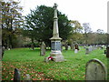
Parish Church of St Peter, Camerton, War Memorial
Image: © Alexander P Kapp
Taken: 24 Oct 2007
0.23 miles
7
Parish Church of St Peter, Camerton
Image: © Alexander P Kapp
Taken: 24 Oct 2007
0.23 miles
8
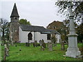
Parish Church of St Peter, Camerton
Image: © Alexander P Kapp
Taken: 24 Oct 2007
0.24 miles