IMAGES TAKEN NEAR TO
Stainburn Road, WORKINGTON, CA14 1SZ
Introduction
This page details the photographs taken nearby to Stainburn Road, CA14 1SZ by members of the Geograph project.
The Geograph project started in 2005 with the aim of publishing, organising and preserving representative images for every square kilometre of Great Britain, Ireland and the Isle of Man.

There are currently over 7.5m images from over14,400 individuals and you can help contribute to the project by visiting https://www.geograph.org.uk
Image Map
Images are licensed for reuse under creativecommons.org/licenses/by-sa/2.0
Notes
- Clicking on the map will re-center to the selected point.
- The higher the marker number, the further away the image location is from the centre of the postcode.
Image Listing (3 Images Found)
Images are licensed for reuse under creativecommons.org/licenses/by-sa/2.0
Image
Details
Distance
1
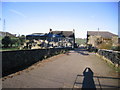
Stainburn Hall Farm
Some maps mark this simply as Hall Farm.
Image: © John Holmes
Taken: 18 Nov 2005
0.11 miles
3
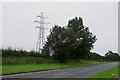
Pylon corner
This corner electricity pylon is on the south side of the old A66 road just 1.2km west of the main crossroad at Great Clifton. It is part of the electricity grid which carries the power from the Whinscales Turbine Complex.
Image: © J P Simpson
Taken: 30 Aug 2008
0.18 miles