IMAGES TAKEN NEAR TO
Stainburn Road, WORKINGTON, CA14 1SW
Introduction
This page details the photographs taken nearby to Stainburn Road, CA14 1SW by members of the Geograph project.
The Geograph project started in 2005 with the aim of publishing, organising and preserving representative images for every square kilometre of Great Britain, Ireland and the Isle of Man.

There are currently over 7.5m images from over14,400 individuals and you can help contribute to the project by visiting https://www.geograph.org.uk
Image Map
Images are licensed for reuse under creativecommons.org/licenses/by-sa/2.0
Notes
- Clicking on the map will re-center to the selected point.
- The higher the marker number, the further away the image location is from the centre of the postcode.
Image Listing (7 Images Found)
Images are licensed for reuse under creativecommons.org/licenses/by-sa/2.0
Image
Details
Distance
1
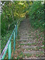
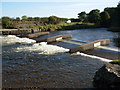
The Yearl steps
footpath from Stainburn to Workington Bridge
Image: © H Stamper
Taken: 1 Oct 2007
0.07 miles
2
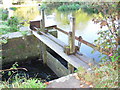
sluice gate
controls the flow into the stream through Hall Park
Image: © H Stamper
Taken: 1 Oct 2007
0.09 miles
6
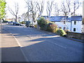
Road Junction outside Briery House.
This used to be the main A66 into Workington now bypassed by A66T
Image: © John Holmes
Taken: 18 Nov 2005
0.19 miles
7
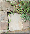
Old Milestone by Stainburn road, 75m west of junction with Moor Road
The Milestone is located in wall on the North of the road. Parish of Workington (Allerdale District). Carved stone post, Carlisle red stone design, erected by the Cockermouth & Workington turnpike trust in the 19th Century. Â
Inscription reads:-
Cockermouth / 7 / Workington / 1
Milestone Society National ID: CU_CMWO07
Image: © Barbara Todd
Taken: 19 Oct 2023
0.20 miles