IMAGES TAKEN NEAR TO
Hunters Close, WORKINGTON, CA14 1QL
Introduction
This page details the photographs taken nearby to Hunters Close, CA14 1QL by members of the Geograph project.
The Geograph project started in 2005 with the aim of publishing, organising and preserving representative images for every square kilometre of Great Britain, Ireland and the Isle of Man.

There are currently over 7.5m images from over14,400 individuals and you can help contribute to the project by visiting https://www.geograph.org.uk
Image Map
Images are licensed for reuse under creativecommons.org/licenses/by-sa/2.0
Notes
- Clicking on the map will re-center to the selected point.
- The higher the marker number, the further away the image location is from the centre of the postcode.
Image Listing (5 Images Found)
Images are licensed for reuse under creativecommons.org/licenses/by-sa/2.0
Image
Details
Distance
1
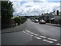
Hunter's Drive
Looking south east from its junction with Barncroft Avenue
Image: © Alexander P Kapp
Taken: 1 Aug 2007
0.08 miles
2
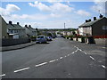
Barncroft Avenue, Seaton
Looking south west from its junction with Hunter's Drive
Image: © Alexander P Kapp
Taken: 1 Aug 2007
0.18 miles
4
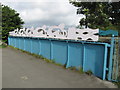
Coast to Coast Themed Art Work on a Bridge Parapet in Cumbria
This plate fabrication added to the parapet of a disused railway bridge in Cumbria depicts cyclists travelling between the seas. The bridge carried the former Cleator & Workington Junction railway over Lowca Lane in Seaton, Cumbria, and is now part of the Coast to Coast Cycle route.
Image: © Andrew Tryon
Taken: 19 Aug 2015
0.24 miles
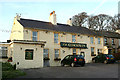
5
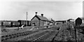
Seaton station, Cleator & Workington Junction Railway, 1951
View eastward, towards Linefoot on branch to Workington Central; closed to passengers 2/22, goods 4/64.
Image: © Walter Dendy, deceased
Taken: 18 Apr 1951
0.25 miles