IMAGES TAKEN NEAR TO
Maryport Road, WORKINGTON, CA14 1NW
Introduction
This page details the photographs taken nearby to Maryport Road, CA14 1NW by members of the Geograph project.
The Geograph project started in 2005 with the aim of publishing, organising and preserving representative images for every square kilometre of Great Britain, Ireland and the Isle of Man.

There are currently over 7.5m images from over14,400 individuals and you can help contribute to the project by visiting https://www.geograph.org.uk
Image Map
Images are licensed for reuse under creativecommons.org/licenses/by-sa/2.0
Notes
- Clicking on the map will re-center to the selected point.
- The higher the marker number, the further away the image location is from the centre of the postcode.
Image Listing (7 Images Found)
Images are licensed for reuse under creativecommons.org/licenses/by-sa/2.0
Image
Details
Distance
2
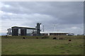
Sewage works with solar and wind power, Siddick
Image: © Stephen Craven
Taken: 15 Mar 2020
0.13 miles
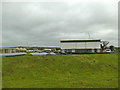
4
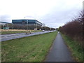
National Cycle Route 72 towards Workington
Beside the A596.
Image: © JThomas
Taken: 23 Nov 2019
0.22 miles
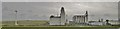
5
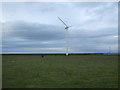
Coastal grazing and wind turbine near Siddick
Image: © JThomas
Taken: 23 Nov 2019
0.24 miles
6
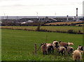
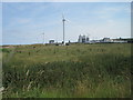
Sheep farm, wind farm and factory
Typical of the proximity of agriculture and industry in West Cumbria. The factory in the middle distance is the Iggesund Board Mill
Image: © Nigel Monckton
Taken: 10 Oct 2004
0.24 miles