IMAGES TAKEN NEAR TO
Camerton, WORKINGTON, CA14 1LR
Introduction
This page details the photographs taken nearby to CA14 1LR by members of the Geograph project.
The Geograph project started in 2005 with the aim of publishing, organising and preserving representative images for every square kilometre of Great Britain, Ireland and the Isle of Man.

There are currently over 7.5m images from over14,400 individuals and you can help contribute to the project by visiting https://www.geograph.org.uk
Image Map
Images are licensed for reuse under creativecommons.org/licenses/by-sa/2.0
Notes
- Clicking on the map will re-center to the selected point.
- The higher the marker number, the further away the image location is from the centre of the postcode.
Image Listing (4 Images Found)
Images are licensed for reuse under creativecommons.org/licenses/by-sa/2.0
Image
Details
Distance
1
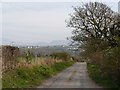
Narrow road to Camerton Church
White houses across the valley to the right are at Great Clifton http://www.geograph.org.uk/photo/80351 .
Image: © Rose and Trev Clough
Taken: 24 Apr 2010
0.03 miles
2
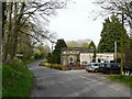
Former lodge to Camerton Hall
An early 19th century grade II listed building http://www.imagesofengland.org.uk/details/default.aspx?id=72241 , now a private house.
The signpost says "Camerton Church", which is accessed by a single track road that passes by the side of the lodge.
Image: © Rose and Trev Clough
Taken: 24 Apr 2010
0.06 miles
3
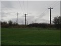
Power lines west of Camerton
A trio of power lines passing over a grass field to the west of Camerton.
Image: © Graham Robson
Taken: 6 Nov 2014
0.19 miles
4
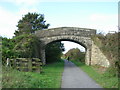
Bridge carrying path towards Seat House Farm
Image: © H Stamper
Taken: 27 Sep 2007
0.22 miles