IMAGES TAKEN NEAR TO
Northside Road, WORKINGTON, CA14 1BE
Introduction
This page details the photographs taken nearby to Northside Road, CA14 1BE by members of the Geograph project.
The Geograph project started in 2005 with the aim of publishing, organising and preserving representative images for every square kilometre of Great Britain, Ireland and the Isle of Man.

There are currently over 7.5m images from over14,400 individuals and you can help contribute to the project by visiting https://www.geograph.org.uk
Image Map
Images are licensed for reuse under creativecommons.org/licenses/by-sa/2.0
Notes
- Clicking on the map will re-center to the selected point.
- The higher the marker number, the further away the image location is from the centre of the postcode.
Image Listing (19 Images Found)
Images are licensed for reuse under creativecommons.org/licenses/by-sa/2.0
Image
Details
Distance
1
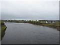
View downstream from the new Northside Bridge
The view downstream, towards the sea, from the newly opened Northside Bridge, Workington. The bridge was officially opened on the 22nd October 2012 by the Princes Royal and replaced the bridge formally on the site which was washed away during flooding in November 2009.
Image: © Graham Robson
Taken: 6 Nov 2012
0.08 miles
2
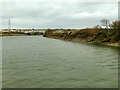
The tidal river Derwent at Workington
One of several rivers in England with this name, this is the one that drains the lake of the same name at Keswick.
Image: © Stephen Craven
Taken: 15 Mar 2020
0.09 miles
3
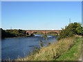
Northside Bridge over the Derwent
The bridge collapsed during the floods of 20 November 2009. A police constable, Bill Barker, who was on the bridge at the time, was killed. His body was later discovered on the beach.
Image: © H Stamper
Taken: 1 Oct 2007
0.10 miles
5
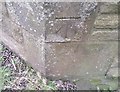
Ordnance Survey Cut Mark
This OS cut mark can be found on the SW face of Holy Trinity Church. It marks a point 10.772m above mean sea level.
Image: © Adrian Dust
Taken: 27 Mar 2018
0.11 miles
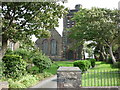
7
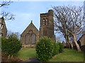
Holy Trinity, West Seaton: mid-February 2015
Image: © Basher Eyre
Taken: 17 Feb 2015
0.12 miles
8
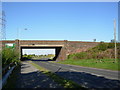
Northside Bridge, Workington
The new, replacement Northside Bridge in Workington. The old bridge on this site was washed away by flooding in November 2009. The new bridge was officially opened by the Princess Royal on the 22nd October 2012.
Image: © Graham Robson
Taken: 6 Nov 2012
0.12 miles
9
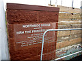
Plaque on Northside Bridge, Workington
The plaque was unveiled on the bridges official opening in the wall on the upstream side of the bridge. The scaffolding boards and metal barrier are evidence that even after the bridge was officially opened work was still ongoing to complete construction work around the periphery of the bridge.
The text on the plaque reads:
Northside Bridge
opened by
HRH The Princess Royal
22 October 2012
Replacing the bridge lost
in the 2009 floods
Built by Cumbria Country Council with
funding from Department for Transport
Image: © Graham Robson
Taken: 6 Nov 2012
0.14 miles
10
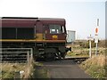
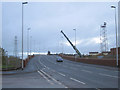
Train crossing the Cumbria Coastal Way
English, Welsh and Scottish Railway Class 66 locomotive number 66181 leaving Workington Docks hauling a freight train, crossing the Cumbria Coastal Way long distance path and National Cycle Route 71 at North Side shortly before reaching the main Cumbrian Coast railway line.
The Cumbria Coastal Way and the Cycle Route were diverted away from this path following the floods in November 2009 which destroyed the Workington Dock Bridge (photograph Image).
The stop sign, equivalent to a red railway stop signal is mandatory. The sign underneath reads ‘Open crossing gates before proceeding’ although there is only one gate to be opened allowing the train to gain access to Network Rail property.
Image: © Adrian Taylor
Taken: 19 Mar 2009
0.14 miles