IMAGES TAKEN NEAR TO
Watermans Walk, CARLISLE, CA1 3TU
Introduction
This page details the photographs taken nearby to Watermans Walk, CA1 3TU by members of the Geograph project.
The Geograph project started in 2005 with the aim of publishing, organising and preserving representative images for every square kilometre of Great Britain, Ireland and the Isle of Man.

There are currently over 7.5m images from over14,400 individuals and you can help contribute to the project by visiting https://www.geograph.org.uk
Image Map
Images are licensed for reuse under creativecommons.org/licenses/by-sa/2.0
Notes
- Clicking on the map will re-center to the selected point.
- The higher the marker number, the further away the image location is from the centre of the postcode.
Image Listing (18 Images Found)
Images are licensed for reuse under creativecommons.org/licenses/by-sa/2.0
Image
Details
Distance
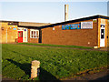
1
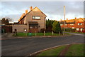
Houses on Meadow View
Ordnance Survey records indicate there that was a benchmark in 1972 on the near house at its right hand corner. The house has been rendered covering the mark. See www.bench-marks.org.uk/bm113576
Image: © Luke Shaw
Taken: 28 Nov 2019
0.13 miles
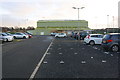
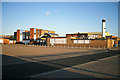
2
Demolition of Harraby Secondary School (4)
Most of the school buildings were demolished in 2013, but the sports hall (green building in the distance) and the theatre https://www.geograph.org.uk/photo/5905198 were retained.
For information about the school, see Image .
Image: © Rose and Trev Clough
Taken: 17 Jul 2013
0.14 miles
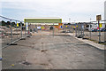
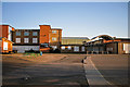
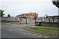
3
Sports Centre off Edgehill Road
The school previously on this site was demolished Image in 2013. The Ordnance Survey benchmark ( www.bench-marks.org.uk/bm113574 ) was then destroyed.
Image: © Luke Shaw
Taken: 28 Nov 2019
0.15 miles
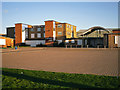
4
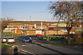
View across Edgehill Road (2012)
Harraby Community Centre in the centre of the picture, with buildings at the former Harraby secondary school in the middle distance.
Zoom shot from Springfield Road.
Image: © Rose and Trev Clough
Taken: 18 Mar 2012
0.17 miles
5
Entrance to Harraby Community Centre (2012)
Since this photo was taken the Community Centre http://www.harrabycommunitycentre.org.uk/ has moved to a new building at Harraby Community Campus, which opened in 2016.
Image: © Rose and Trev Clough
Taken: 18 Mar 2012
0.17 miles
6
The former Harraby Secondary School (2)
For more information see Image .
Photo taken 2012 shows premises boarded up. Demolished 2013.
Image: © Rose and Trev Clough
Taken: 18 Mar 2012
0.18 miles
7
The former Harraby Secondary School (3)
For more information see Image .
Most of the buildings were demolished in 2013. The sports hall (green corrugated structure behind low building at centre of picture) was retained, along with the theatre.
Image: © Rose and Trev Clough
Taken: 18 Mar 2012
0.18 miles
8
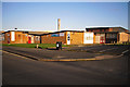
Harraby Community Centre (2012)
Since this photo was taken facilities have been moved to a new building at Harraby Community Campus, further along Edgehill Road, which opened in 2016.
Image: © Rose and Trev Clough
Taken: 18 Mar 2012
0.18 miles
9
The former Harraby Secondary School (1)
Harraby Secondary Modern School, Edgehill Road, was opened in 1956. When comprehensive education was introduced in the late 1960s, it became Harraby Secondary. In the 1990s the school attained specialist status and was renamed North Cumbria Technology College.
In 2008 the college was merged with St Aidan's County High School https://www.geograph.org.uk/photo/5904932 to create the Richard Rose Central Academy, which was based initially at the Harraby site above. Early in 2011 the academy relocated to its newly built accommodation on land vacated by the demolition of St Aidan's School.
Most of the former Harraby School was demolished in 2013 (photo https://www.geograph.org.uk/photo/5905211 ), and Harraby Community Campus was constructed in the grounds https://www.atkinsglobal.com/en-gb/projects/harraby-community-campus .
Image: © Rose and Trev Clough
Taken: 18 Mar 2012
0.18 miles
10
Demolition of Harraby Secondary School (1)
For information about the school, see Image .
When this photo was taken, most of the site had already been cleared.
Image: © Rose and Trev Clough
Taken: 17 Jul 2013
0.19 miles