IMAGES TAKEN NEAR TO
Beverley Rise, CARLISLE, CA1 3RY
Introduction
This page details the photographs taken nearby to Beverley Rise, CA1 3RY by members of the Geograph project.
The Geograph project started in 2005 with the aim of publishing, organising and preserving representative images for every square kilometre of Great Britain, Ireland and the Isle of Man.

There are currently over 7.5m images from over14,400 individuals and you can help contribute to the project by visiting https://www.geograph.org.uk
Image Map
Images are licensed for reuse under creativecommons.org/licenses/by-sa/2.0
Notes
- Clicking on the map will re-center to the selected point.
- The higher the marker number, the further away the image location is from the centre of the postcode.
Image Listing (19 Images Found)
Images are licensed for reuse under creativecommons.org/licenses/by-sa/2.0
Image
Details
Distance
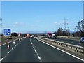
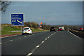
7
M6 north approaching Junction 43 sign
This is the half mile sign just before the railway underbridge
Image: © John Firth
Taken: 9 May 2012
0.15 miles
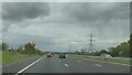
8
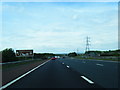
City of Carlisle : The M6 Motorway
Heading north on the M6 Motorway through Cumbria.
Image: © Lewis Clarke
Taken: 22 Apr 2016
0.16 miles
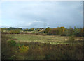
9
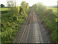
M6 bridge
M6 bridge over Settle to Carlisle Railway seen from bridge on minor road U1184 to St Brelades
Image: © Rose and Trev Clough
Taken: 26 May 2007
0.17 miles