IMAGES TAKEN NEAR TO
St. Elizabeths Close, CARLISLE, CA1 3RB
Introduction
This page details the photographs taken nearby to St. Elizabeths Close, CA1 3RB by members of the Geograph project.
The Geograph project started in 2005 with the aim of publishing, organising and preserving representative images for every square kilometre of Great Britain, Ireland and the Isle of Man.

There are currently over 7.5m images from over14,400 individuals and you can help contribute to the project by visiting https://www.geograph.org.uk
Image Map
Images are licensed for reuse under creativecommons.org/licenses/by-sa/2.0
Notes
- Clicking on the map will re-center to the selected point.
- The higher the marker number, the further away the image location is from the centre of the postcode.
Image Listing (27 Images Found)
Images are licensed for reuse under creativecommons.org/licenses/by-sa/2.0
Image
Details
Distance
1
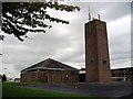
St Elisabeth's Church, Harraby, Carlisle
Built I believe in the late 1950s or early 60s with complete lack of style, at least externally. It looks more like a fire station than a church.
Image: © Brian Norman
Taken: 22 Oct 2006
0.03 miles
2
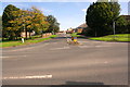
Junction of Arnside Road with Eastern Way
Image: © Roger Templeman
Taken: 24 Aug 2019
0.05 miles
3

The Inglewood, Harraby
Located in Pennine Way, photo taken shortly before demolition in 2010. The pub was originally called The Inglewood Forest, the name was shortened fairly recently. It opened in 1953 (information from Carlisle Encyclopaedia website http://www.carlisleshistory.co.uk/page49.htm ), and had a bowling green (out of shot, to the right).
Image: © Rose and Trev Clough
Taken: 30 Aug 2010
0.07 miles
4
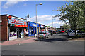
Central Avenue, Post Office and shops
Part of a busy shopping precinct in the Carlisle suburb of Harraby.
Image: © Rose and Trev Clough
Taken: 22 May 2013
0.08 miles
5

Site of "Inglewood Forest" pub, Harraby - October 2017
The "Inglewood Forest" is Carlisle's forgotten pub - receiving not even a mention in the final chapter of "The Carlisle State Management Scheme", written by her son after Olive Seabury's death in 2005. However, it was a Scheme "new build", opening on 21 October 1953 and complete with a bowling green, private garden and car park. While it served a then expanding housing estate, it does not appear to have prospered even after sale to the private sector in 1973. The pub closed in 2007 and was demolished in 2010. The building seen here is built on the site and is a residential and day care centre.
A Rose & Trev Clough photograph taken just before demolition can be seen: Image] .
Image: © The Carlisle Kid
Taken: 29 Oct 2017
0.08 miles
6
ITV Border, Brunel Way
The original name "Border Television" was changed in 2006, not long after the business became part of ITV plc. For background information, see Image .
In its later years the station's main output was local news, including the popular magazine programme "Lookaround" (commonly referred to as "Border Crack 'n' Deekaboot"). A big campaign to keep its production in Carlisle could not stop ITV from transferring operations to Gateshead, now the centre for a merged Tyne Tees and Border regional news service.
The last broadcast from this studio was on 24 February 2009. 51 jobs were lost at Border; 13 staff were retained to cover the area's news, with a much smaller new base at Kingstown, Carlisle.
These studios at Durranhill were sold, and demolished in 2010 - see http://www.geograph.org.uk/photo/2219886
Image: © Rose and Trev Clough
Taken: 24 Apr 2009
0.10 miles
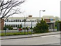
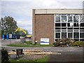
7

Carlisle East Community Fire Station
The recently opened Carlisle East Community Fire Station. The station officially opened in July 2012.
Image: © Graham Robson
Taken: 3 Nov 2013
0.11 miles
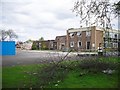
8
Demolition of Border TV Studios
The premises were vacated by ITV Border in 2009 (see Geograph photos http://www.geograph.org.uk/photo/2219850 and http://www.geograph.org.uk/photo/2219833 ) and bought by Carlisle City Council.
The sign says "Durranhill Industrial Estate Regeneration Scheme" - a partnership between Carlisle City and Cumbria County Councils, supported by the Northwest Development Agency.
They are hoping to attract new businesses to boost the local economy and employment.
Image: © Rose and Trev Clough
Taken: 10 May 2010
0.11 miles
9

Carlisle East Community Fire Station
This station, and a smaller one at Carlisle West, opened in 2012. The Fire and Rescue Service relocated from Warwick Street, where it had been based since 1940 Image .
Image: © Rose and Trev Clough
Taken: 12 Jul 2013
0.11 miles
10
Bye bye Border
Demolition of Border Television studios at Durranhill. 48 years of broadcasting from this site came to an end in 2009 - for more information see Geograph entries http://www.geograph.org.uk/photo/2219833 & http://www.geograph.org.uk/photo/2219850 .
Image: © Rose and Trev Clough
Taken: 10 May 2010
0.11 miles