IMAGES TAKEN NEAR TO
Pennine Way, CARLISLE, CA1 3QP
Introduction
This page details the photographs taken nearby to Pennine Way, CA1 3QP by members of the Geograph project.
The Geograph project started in 2005 with the aim of publishing, organising and preserving representative images for every square kilometre of Great Britain, Ireland and the Isle of Man.

There are currently over 7.5m images from over14,400 individuals and you can help contribute to the project by visiting https://www.geograph.org.uk
Image Map
Images are licensed for reuse under creativecommons.org/licenses/by-sa/2.0
Notes
- Clicking on the map will re-center to the selected point.
- The higher the marker number, the further away the image location is from the centre of the postcode.
Image Listing (30 Images Found)
Images are licensed for reuse under creativecommons.org/licenses/by-sa/2.0
Image
Details
Distance
1
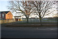
Security fencing for Newman Catholic School on south side of Pennine Way
Previously there was a wall here with an Ordnance Survey benchmark, see https://www.bench-marks.org.uk/bm113440
Image: © Luke Shaw
Taken: 18 Nov 2019
0.06 miles
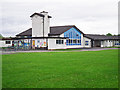
2
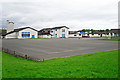
Pennine Way Primary School (1)
View across the playground, from Tindale Drive.
The school opened in the mid 1950s. This site was vacated in December 2015, when the school relocated to a new building on Edgehill Road.
Image: © Rose and Trev Clough
Taken: 24 May 2015
0.07 miles
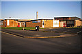
3
Pennine Way Primary School (2)
One of the entrances to the building, seen from Tindale Drive.
The school opened in the mid 1950s. This site was vacated in December 2015, when the school relocated to a new building on Edgehill Road.
Image: © Rose and Trev Clough
Taken: 24 May 2015
0.07 miles
4

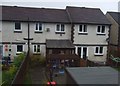
#3 Linden Terrace
Ordnance Survey records indicate the presence of a benchmark on a brick post in 1972 at a works enclosure. I assume the 'works' refers to an electricity substation. There are brick gateposts at the entrance to an EES left of the house, but no sign of a benchmark on them. See www.bench-marks.org.uk/bm113573
Image: © Luke Shaw
Taken: 28 Nov 2019
0.10 miles
5
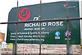
Demolition of Harraby Secondary School (5)
Sign for the Richard Rose Central Academy, which was based here during the early years of its establishment (for information see Image).
For a wider view of the location, see Image
Image: © Rose and Trev Clough
Taken: 17 Jul 2013
0.21 miles
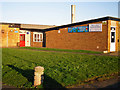
6
Harraby Community Centre (2012)
Since this photo was taken facilities have been moved to a new building at Harraby Community Campus, further along Edgehill Road, which opened in 2016.
Image: © Rose and Trev Clough
Taken: 18 Mar 2012
0.21 miles
7
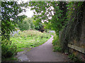
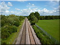
Path between two railways
View from underneath a bridge on the Newcastle-Carlisle Railway, off Pasture Walk, Durranhill. Looking towards another bridge, on the Settle-Carlisle Railway, where the path goes through to Keenan Park in Harraby.
See also Image .
Image: © Rose and Trev Clough
Taken: 18 Sep 2013
0.21 miles
8
Entrance to Harraby Community Centre (2012)
Since this photo was taken the Community Centre http://www.harrabycommunitycentre.org.uk/ has moved to a new building at Harraby Community Campus, which opened in 2016.
Image: © Rose and Trev Clough
Taken: 18 Mar 2012
0.21 miles