IMAGES TAKEN NEAR TO
Pennine Way, CARLISLE, CA1 3QL
Introduction
This page details the photographs taken nearby to Pennine Way, CA1 3QL by members of the Geograph project.
The Geograph project started in 2005 with the aim of publishing, organising and preserving representative images for every square kilometre of Great Britain, Ireland and the Isle of Man.

There are currently over 7.5m images from over14,400 individuals and you can help contribute to the project by visiting https://www.geograph.org.uk
Image Map
Images are licensed for reuse under creativecommons.org/licenses/by-sa/2.0
Notes
- Clicking on the map will re-center to the selected point.
- The higher the marker number, the further away the image location is from the centre of the postcode.
Image Listing (31 Images Found)
Images are licensed for reuse under creativecommons.org/licenses/by-sa/2.0
Image
Details
Distance
1

#3 Linden Terrace
Ordnance Survey records indicate the presence of a benchmark on a brick post in 1972 at a works enclosure. I assume the 'works' refers to an electricity substation. There are brick gateposts at the entrance to an EES left of the house, but no sign of a benchmark on them. See www.bench-marks.org.uk/bm113573
Image: © Luke Shaw
Taken: 28 Nov 2019
0.04 miles
2
Security fencing for Newman Catholic School on south side of Pennine Way
Previously there was a wall here with an Ordnance Survey benchmark, see https://www.bench-marks.org.uk/bm113440
Image: © Luke Shaw
Taken: 18 Nov 2019
0.12 miles
3
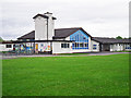
Pennine Way Primary School (2)
One of the entrances to the building, seen from Tindale Drive.
The school opened in the mid 1950s. This site was vacated in December 2015, when the school relocated to a new building on Edgehill Road.
Image: © Rose and Trev Clough
Taken: 24 May 2015
0.12 miles
4
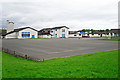
Pennine Way Primary School (1)
View across the playground, from Tindale Drive.
The school opened in the mid 1950s. This site was vacated in December 2015, when the school relocated to a new building on Edgehill Road.
Image: © Rose and Trev Clough
Taken: 24 May 2015
0.13 miles
5
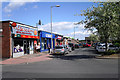
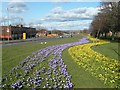
Central Avenue, Post Office and shops
Part of a busy shopping precinct in the Carlisle suburb of Harraby.
Image: © Rose and Trev Clough
Taken: 22 May 2013
0.17 miles
6
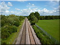
Eastern Way, Carlisle
This road between Harraby and Botcherby was constructed as part of a 1960's ring road scheme for the city, which never got completed. Buildings on the left are at Durranhill Industrial Estate, on the right is the Harraby housing estate.
Image: © Rose and Trev Clough
Taken: 4 Mar 2008
0.17 miles

9

Benchmark on step at NW end of Westville
Ordnance Survey pivot benchmark described on the Bench Mark Database at https://www.bench-marks.org.uk/bm113437
Image: © Luke Shaw
Taken: 18 Nov 2019
0.19 miles
10

Site of "Inglewood Forest" pub, Harraby - October 2017
The "Inglewood Forest" is Carlisle's forgotten pub - receiving not even a mention in the final chapter of "The Carlisle State Management Scheme", written by her son after Olive Seabury's death in 2005. However, it was a Scheme "new build", opening on 21 October 1953 and complete with a bowling green, private garden and car park. While it served a then expanding housing estate, it does not appear to have prospered even after sale to the private sector in 1973. The pub closed in 2007 and was demolished in 2010. The building seen here is built on the site and is a residential and day care centre.
A Rose & Trev Clough photograph taken just before demolition can be seen: Image] .
Image: © The Carlisle Kid
Taken: 29 Oct 2017
0.20 miles