IMAGES TAKEN NEAR TO
Telford Road, CARLISLE, CA1 3NN
Introduction
This page details the photographs taken nearby to Telford Road, CA1 3NN by members of the Geograph project.
The Geograph project started in 2005 with the aim of publishing, organising and preserving representative images for every square kilometre of Great Britain, Ireland and the Isle of Man.

There are currently over 7.5m images from over14,400 individuals and you can help contribute to the project by visiting https://www.geograph.org.uk
Image Map
Images are licensed for reuse under creativecommons.org/licenses/by-sa/2.0
Notes
- Clicking on the map will re-center to the selected point.
- The higher the marker number, the further away the image location is from the centre of the postcode.
Image Listing (28 Images Found)
Images are licensed for reuse under creativecommons.org/licenses/by-sa/2.0
Image
Details
Distance
1
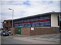
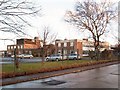
Cumbria Constabulary, North Area HQ
Headquarters for North Cumbria operational area covering the districts of Carlisle and Eden http://www.cumbria.police.uk/about-us/area-structure-services . Situated in Brunel Way, Durranhill Industrial Estate.
Opened in May 2009, the building was designed with environmental sustainability as a priority. Features include grassed roof areas, rainwater harvesting, ground source heat exchangers and solar panels. Interior views available on BBC website - http://www.bbc.co.uk/cumbria/content/image_galleries/police_station_carlisle_new_20090417_gallery.shtml?1 .
Image: © Rose and Trev Clough
Taken: 10 May 2010
0.10 miles
2
Durranhill Industrial estate
The entrance road to the estate, at the brow of the hill.
Image: © Roger May
Taken: 9 Aug 2005
0.11 miles
3
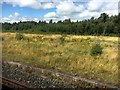
Durranhill Sidings
Viewed from a passing steam-hauled train on The Dalesman excursion to the Settle-Carlisle line and seemingly abandoned some time ago
Image: © Graham Hogg
Taken: 7 Aug 2017
0.16 miles
4
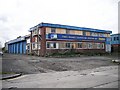
HiQ Tyreservices, up for sale
Looks like it's been closed for some time. Frontage on Brunel Way, Durranhill Industrial Estate.
Information update : the building was demolished in 2017.
Image: © Rose and Trev Clough
Taken: 10 May 2010
0.16 miles
5

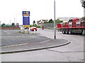
Carlisle East Community Fire Station
This station, and a smaller one at Carlisle West, opened in 2012. The Fire and Rescue Service relocated from Warwick Street, where it had been based since 1940 Image .
Image: © Rose and Trev Clough
Taken: 12 Jul 2013
0.18 miles
6
Bye bye Border
Demolition of Border Television studios at Durranhill. 48 years of broadcasting from this site came to an end in 2009 - for more information see Geograph entries http://www.geograph.org.uk/photo/2219833 & http://www.geograph.org.uk/photo/2219850 .
Image: © Rose and Trev Clough
Taken: 10 May 2010
0.18 miles
7
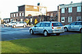
ITV Border News cars (2009)
Parked at the Border TV studios. The building was demolished in 2010.
For more information, see Image .
Image: © Rose and Trev Clough
Taken: 25 Jan 2009
0.18 miles
8
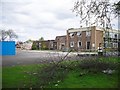
Border Television Studios
Border Television, a regional independent station, started broadcasting from this purpose-built centre at Durranhill in 1961. Transmissions covered Cumberland, Westmorland, southern Scotland, parts of Northumberland, and later the Isle of Man.
Since 2000 the business was sold twice, and following a merger in 2004 it became part of ITV plc. The latter restructured its regional news provision in 2009, when cost-cutting measures included the merger of Border with its neighbour Tyne Tees. Local news for the Border region is now broadcast from Gateshead.
For more information see Image .
The studios were demolished in 2010 http://www.geograph.org.uk/photo/2219886 .
Image: © Rose and Trev Clough
Taken: 25 Jan 2009
0.18 miles
9

Carlisle East Community Fire Station
The recently opened Carlisle East Community Fire Station. The station officially opened in July 2012.
Image: © Graham Robson
Taken: 3 Nov 2013
0.18 miles
10

Nearing Carlisle
Leaving the Settle to Carlisle line and entering the main southern junction.
Image: © Ashley Dace
Taken: 9 Oct 2010
0.18 miles