IMAGES TAKEN NEAR TO
Hillary Grove, CARLISLE, CA1 3GZ
Introduction
This page details the photographs taken nearby to Hillary Grove, CA1 3GZ by members of the Geograph project.
The Geograph project started in 2005 with the aim of publishing, organising and preserving representative images for every square kilometre of Great Britain, Ireland and the Isle of Man.

There are currently over 7.5m images from over14,400 individuals and you can help contribute to the project by visiting https://www.geograph.org.uk
Image Map
Images are licensed for reuse under creativecommons.org/licenses/by-sa/2.0
Notes
- Clicking on the map will re-center to the selected point.
- The higher the marker number, the further away the image location is from the centre of the postcode.
Image Listing (27 Images Found)
Images are licensed for reuse under creativecommons.org/licenses/by-sa/2.0
Image
Details
Distance
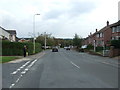
2
Harraby housing
A view looking to the southeast along Cumwhinton Road in the residential area of Harraby.
Image: © Phil Williams
Taken: 17 Feb 2007
0.04 miles
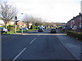
4
Edgehill Road
A large housing area in the Harraby area of Carlisle.
Image: © Mary and Angus Hogg
Taken: 20 Feb 2018
0.14 miles
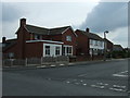
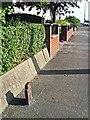
5
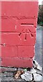
Benchmark on #30 Cumwhinton Road
Ordnance Survey cut mark benchmark levelled at 44.028m above Newlyn Datum verified 1972
Image: © Roger Templeman
Taken: 21 Oct 2021
0.15 miles
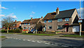
6
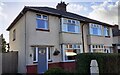
Nos. 30 and 28 Cumwhinton Road
There is an Ordnance Survey benchmark Image on the left hand side of the left hand house at its front corner
Image: © Roger Templeman
Taken: 21 Oct 2021
0.16 miles
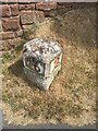
7
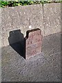
Benchmark on Penrith 16 milestone outside #405 London Road ('Two Miles')
Ordnance Survey pivot benchmark described on the Bench Mark Database at www.bench-marks.org.uk/bm74946
The mark was levelled at 45.350m above Newlyn Datum verified 1972, and at 148.702 feet above Liverpool Datum during the 1841/44 Liverpool to Port Carlisle 1GL Survey.
Image: © Roger Templeman
Taken: 21 Oct 2021
0.19 miles
8
Old GPO telephone cable marker (3), close up
For situation see Image .
There would have been numbers attached to this iron post, indicating the distance in feet and inches to an underground telephone cable or junction.
Presumably installed during the reign of Edward VII (1901-1910), as the initials ER appear around the crown at the top. At the bottom of the post is an arrow, which was used to denote government property (including prisoners' uniforms).
When this marker was installed, the General Post Office (GPO) owned most of the telephone network in the UK. Later cable markers were made of concrete, and had 'GPO' stamped upon them - see Image .
Disappointingly, the back of this marker was plain rusty metal with no writing on it.
Image: © Rose and Trev Clough
Taken: 3 Oct 2016
0.19 miles
9
Old GPO telephone cable marker, London Road (3)
The function of this iron plate sticking out of the footpath was to indicate the position of a buried telephone cable or junction. It must be more than 100 years old. For more information, see Image .
This is London Road (A6) at Harraby, looking away from the town. There are more examples along this road, one nearby http://www.geograph.org.uk/photo/5222642 and two below Summer Hill http://www.geograph.org.uk/photo/5222637 & http://www.geograph.org.uk/photo/5222638 .
Image: © Rose and Trev Clough
Taken: 3 Oct 2016
0.19 miles
10
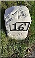
Old Milestone by the A6, London Road, Carlisle
Metal plates attached to stone post by the A6, in parish of Carlisle (Carlisle District), London Road, by No. 405, in Carleton, 50m North West of junction with Blundell Road, by drive entrance in pavement with back to a wall, on East side of road. Carlisle red stone numeral, erected by the Carlisle & Eamont Bridge Turnpike Trust in the 19th century.
Inscription reads:-
: 16 : : 2 :
Carved benchmark on top.
Grade II listed. List Entry Number: 1196926
https://historicengland.org.uk/listing/the-list/list-entry/1196926
Milestone Society National ID: CU_PRCL16.
Image: © Milestone Society
Taken: 28 May 2017
0.19 miles