IMAGES TAKEN NEAR TO
Carleton, CARLISLE, CA1 3DY
Introduction
This page details the photographs taken nearby to CA1 3DY by members of the Geograph project.
The Geograph project started in 2005 with the aim of publishing, organising and preserving representative images for every square kilometre of Great Britain, Ireland and the Isle of Man.

There are currently over 7.5m images from over14,400 individuals and you can help contribute to the project by visiting https://www.geograph.org.uk
Image Map
Images are licensed for reuse under creativecommons.org/licenses/by-sa/2.0
Notes
- Clicking on the map will re-center to the selected point.
- The higher the marker number, the further away the image location is from the centre of the postcode.
Image Listing (21 Images Found)
Images are licensed for reuse under creativecommons.org/licenses/by-sa/2.0
Image
Details
Distance
1
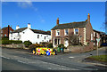
Houses at Carleton
The last houses in the settlement, located on the A6.
Image: © Mary and Angus Hogg
Taken: 20 Feb 2018
0.06 miles
2
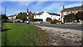
Houses on NE side of A6 at Carleton from SW side of the road
There is a Cumberland County Council signpost Image in the verge on the near side of the A6
Image: © Roger Templeman
Taken: 21 Oct 2021
0.08 miles
3
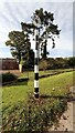
Fingerless Cumberland County Council signpost on SW side of A6 opposite Park End
The signpost has Milestone Society National ID: CU_NY4252
Image: © Roger Templeman
Taken: 21 Oct 2021
0.08 miles
4
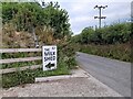
Sign for The Milk Shed
Popular self-service milk vending at The Beeches Farm.
Image: © David Bremner
Taken: 14 Jul 2021
0.09 miles
5
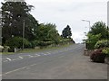
A6, Carleton
Southern approach to Carlisle and the pre-M6 main road.
Image: © Richard Webb
Taken: 28 Jun 2014
0.09 miles
6
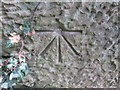
Ordnance Survey 1GL Bolt
This OS Bolt can be found on the NE face of the Relton's Bridge. It marks a point 35.092m above mean sea level.
Image: © Adrian Dust
Taken: 11 Apr 2016
0.11 miles
7
Benchmark on Relton's Bridge
Ordnance Survey 1GL bolt benchmark levelled at 35.092m above Newlyn Datum verified in 1972. See www.bench-marks.org.uk/bm24804
The mark was originally levelled at 114.798 feet above Liverpool Datum during the 1841/4 Liverpool to Port Carlisle 1GL Survey. The surveyor's description was 'No. 461. Bolt in stone at spring of arch of N.W. pier of Relton's Bridge ; 11.15 ft. below top of parapet'
Image: © Roger Templeman
Taken: 21 Oct 2021
0.11 miles
8
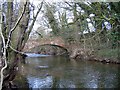
Bridge over the River Petteril
The photo is not lopsided. The bridge slopes upwards from the west riverbank up towards the A6 at Carleton.
Image: © Brian Norman
Taken: 23 Feb 2013
0.12 miles
9
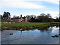
Carleton Mill
View of the restored mill (now a residence) from across the River Petteril.
Image: © Brian Norman
Taken: 23 Feb 2013
0.12 miles
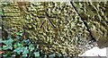
10
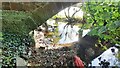
River Petteril at Relton's Bridge
There is an Ordnance Survey Image on the stone in the bridge wall left of the bottom arch stone
Image: © Roger Templeman
Taken: 21 Oct 2021
0.13 miles