IMAGES TAKEN NEAR TO
Woodsghyll Drive, CARLISLE, CA1 3DD
Introduction
This page details the photographs taken nearby to Woodsghyll Drive, CA1 3DD by members of the Geograph project.
The Geograph project started in 2005 with the aim of publishing, organising and preserving representative images for every square kilometre of Great Britain, Ireland and the Isle of Man.

There are currently over 7.5m images from over14,400 individuals and you can help contribute to the project by visiting https://www.geograph.org.uk
Image Map
Images are licensed for reuse under creativecommons.org/licenses/by-sa/2.0
Notes
- Clicking on the map will re-center to the selected point.
- The higher the marker number, the further away the image location is from the centre of the postcode.
Image Listing (28 Images Found)
Images are licensed for reuse under creativecommons.org/licenses/by-sa/2.0
Image
Details
Distance
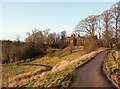
1
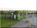
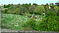
Gate in Petteril Valley Park
Near the end of Woodsghyll Drive. The gate separates an area with mown grass from rough vegetation down the slope.
With good views over the Petteril Valley, the park has hay meadows, a small wood and riverside walks. It belongs to Carlisle City Council, whose old website had some interesting information now only available from Internet Archive - see Petteril Valley natural history http://web.archive.org/web/20130424135210/http://www.carlisle.gov.uk/leisure_and_culture/parks_and_open_spaces/park_locations/petteril_valley/petteril_valley_nat_history.aspx and wildlife http://web.archive.org/web/20130424125847/http://www.carlisle.gov.uk/leisure_and_culture/parks_and_open_spaces/park_locations/petteril_valley/petteril_valley_wildlife.aspx .
Image: © Rose and Trev Clough
Taken: 31 Oct 2010
0.05 miles
2
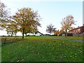
Green space behind Dale End Road
The white house is at the end of Woodsghyll Drive. Near the back of the property is Image .
Image: © Rose and Trev Clough
Taken: 31 Oct 2010
0.07 miles
3
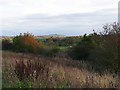
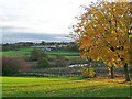
View from Petteril Valley Park
Semi-natural vegetation on a slope down to the River Petteril. The scrub is at the eastern end of Dicky Wood.
The hill in the distance is Barrock Fell, several kilometres away at Image .
Image: © Rose and Trev Clough
Taken: 31 Oct 2010
0.10 miles
4
The River Petteril
Children playing by the river at the footbridge near Dicky Wood. Viewed from a Glasgow bound train.
Image: © Thomas Nugent
Taken: 18 Apr 2014
0.11 miles
5
The River Petteril
Children playing by the river at the footbridge near Dicky Wood. Viewed from a Glasgow bound train.
Image: © Thomas Nugent
Taken: 18 Apr 2014
0.11 miles
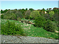
7
Park overlooking the River Petteril
View from Petteril Valley Park near Dale End Road, Harraby.
The house is at Woodbank near Brisco, next to the West Coast Main Line railway.
Image: © Rose and Trev Clough
Taken: 31 Oct 2010
0.14 miles
8
Open Space Near Carleton
This area of open space lies high above the River Petteril on the south side of Carlisle. The houses in the background lie along the A6.
Image: © Mary and Angus Hogg
Taken: 20 Feb 2018
0.17 miles
9
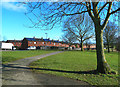
Recently laid pathways at Petteril Bank
The path on the left leads to the Petteril valley - popular with dog walkers. The one on the right goes to Image, seen through the trees.
Image: © Rose and Trev Clough
Taken: 25 Jan 2009
0.20 miles
10
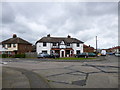
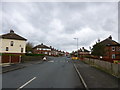
Carlisle, Barnardo's Community House
Sure Start Centre on Blundell Road: http://www.barnardos.org.uk/carlislesouthcc.htm
Image: © Mike Faherty
Taken: 15 May 2012
0.21 miles