IMAGES TAKEN NEAR TO
Lightfoot Drive, CARLISLE, CA1 3BL
Introduction
This page details the photographs taken nearby to Lightfoot Drive, CA1 3BL by members of the Geograph project.
The Geograph project started in 2005 with the aim of publishing, organising and preserving representative images for every square kilometre of Great Britain, Ireland and the Isle of Man.

There are currently over 7.5m images from over14,400 individuals and you can help contribute to the project by visiting https://www.geograph.org.uk
Image Map
Images are licensed for reuse under creativecommons.org/licenses/by-sa/2.0
Notes
- Clicking on the map will re-center to the selected point.
- The higher the marker number, the further away the image location is from the centre of the postcode.
Image Listing (47 Images Found)
Images are licensed for reuse under creativecommons.org/licenses/by-sa/2.0
Image
Details
Distance
2
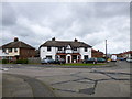
Carlisle, Barnardo's Community House
Sure Start Centre on Blundell Road: http://www.barnardos.org.uk/carlislesouthcc.htm
Image: © Mike Faherty
Taken: 15 May 2012
0.10 miles
3
Carlisle, Google Earth car
On Welsh Road, preparing for a day's work re-surveying Carlisle's suburbs.
Image: © Mike Faherty
Taken: 15 May 2012
0.12 miles
4
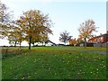
Green space behind Dale End Road
The white house is at the end of Woodsghyll Drive. Near the back of the property is Image .
Image: © Rose and Trev Clough
Taken: 31 Oct 2010
0.14 miles
5
Carlisle Milestone
Beside London Road; 2 miles from Carlisle and 16 miles to Penrith.
Image: © David Rogers
Taken: 8 Oct 2009
0.14 miles
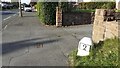
6
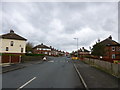
London Road, Carlisle
16 miles to Penrith along the old Roman Road.
Image: © David Rogers
Taken: 8 Oct 2009
0.15 miles
7
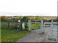
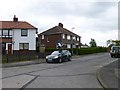
Gate in Petteril Valley Park
Near the end of Woodsghyll Drive. The gate separates an area with mown grass from rough vegetation down the slope.
With good views over the Petteril Valley, the park has hay meadows, a small wood and riverside walks. It belongs to Carlisle City Council, whose old website had some interesting information now only available from Internet Archive - see Petteril Valley natural history http://web.archive.org/web/20130424135210/http://www.carlisle.gov.uk/leisure_and_culture/parks_and_open_spaces/park_locations/petteril_valley/petteril_valley_nat_history.aspx and wildlife http://web.archive.org/web/20130424125847/http://www.carlisle.gov.uk/leisure_and_culture/parks_and_open_spaces/park_locations/petteril_valley/petteril_valley_wildlife.aspx .
Image: © Rose and Trev Clough
Taken: 31 Oct 2010
0.15 miles
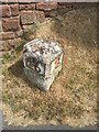
8
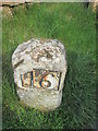
Milestone - Carlisle 2
There is an OS pivot on the milestone. It marks a point 45.35m above mean sea level.
Image: © Adrian Dust
Taken: 11 Apr 2016
0.15 miles
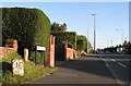
9
Milestone (for Carlisle 2) outside house named 'Two Miles' on NE side of London Road
An image of the other face of the milestone is at Image
The milestone has Milestone Society National ID: CU_PRCL16
Image: © Roger Templeman
Taken: 21 Oct 2021
0.16 miles
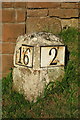
10
Old Milestone by the A6, London Road, Carlisle
Metal plates attached to stone post by the A6, in parish of Carlisle (Carlisle District), London Road, by No. 405, in Carleton, 50m North West of junction with Blundell Road, by drive entrance in pavement with back to a wall, on East side of road. Carlisle red stone numeral, erected by the Carlisle & Eamont Bridge Turnpike Trust in the 19th century.
Inscription reads:-
: 16 : : 2 :
Carved benchmark on top.
Grade II listed. List Entry Number: 1196926
https://historicengland.org.uk/listing/the-list/list-entry/1196926
Milestone Society National ID: CU_PRCL16.
Image: © Milestone Society
Taken: 28 May 2017
0.16 miles