IMAGES TAKEN NEAR TO
Semple Road, CARLISLE, CA1 3AZ
Introduction
This page details the photographs taken nearby to Semple Road, CA1 3AZ by members of the Geograph project.
The Geograph project started in 2005 with the aim of publishing, organising and preserving representative images for every square kilometre of Great Britain, Ireland and the Isle of Man.

There are currently over 7.5m images from over14,400 individuals and you can help contribute to the project by visiting https://www.geograph.org.uk
Image Map
Images are licensed for reuse under creativecommons.org/licenses/by-sa/2.0
Notes
- Clicking on the map will re-center to the selected point.
- The higher the marker number, the further away the image location is from the centre of the postcode.
Image Listing (34 Images Found)
Images are licensed for reuse under creativecommons.org/licenses/by-sa/2.0
Image
Details
Distance
1
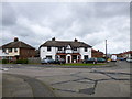
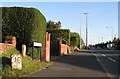
Carlisle, Barnardo's Community House
Sure Start Centre on Blundell Road: http://www.barnardos.org.uk/carlislesouthcc.htm
Image: © Mike Faherty
Taken: 15 May 2012
0.04 miles
2
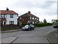
Carlisle, Google Earth car
On Welsh Road, preparing for a day's work re-surveying Carlisle's suburbs.
Image: © Mike Faherty
Taken: 15 May 2012
0.06 miles
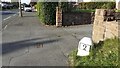
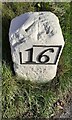
4
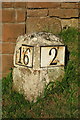
Carlisle Milestone
Beside London Road; 2 miles from Carlisle and 16 miles to Penrith.
Image: © David Rogers
Taken: 8 Oct 2009
0.08 miles
5
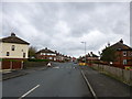
London Road, Carlisle
16 miles to Penrith along the old Roman Road.
Image: © David Rogers
Taken: 8 Oct 2009
0.10 miles
6
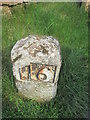
Milestone - Carlisle 2
There is an OS pivot on the milestone. It marks a point 45.35m above mean sea level.
Image: © Adrian Dust
Taken: 11 Apr 2016
0.10 miles
7
Milestone (for Carlisle 2) outside house named 'Two Miles' on NE side of London Road
An image of the other face of the milestone is at Image
The milestone has Milestone Society National ID: CU_PRCL16
Image: © Roger Templeman
Taken: 21 Oct 2021
0.10 miles
8
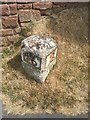
Old Milestone by the A6, London Road, Carlisle
Metal plates attached to stone post by the A6, in parish of Carlisle (Carlisle District), London Road, by No. 405, in Carleton, 50m North West of junction with Blundell Road, by drive entrance in pavement with back to a wall, on East side of road. Carlisle red stone numeral, erected by the Carlisle & Eamont Bridge Turnpike Trust in the 19th century.
Inscription reads:-
: 16 : : 2 :
Carved benchmark on top.
Grade II listed. List Entry Number: 1196926
https://historicengland.org.uk/listing/the-list/list-entry/1196926
Milestone Society National ID: CU_PRCL16.
Image: © Milestone Society
Taken: 28 May 2017
0.10 miles
9
Benchmark on Penrith 16 milestone outside #405 London Road ('Two Miles')
Ordnance Survey pivot benchmark described on the Bench Mark Database at www.bench-marks.org.uk/bm74946
The mark was levelled at 45.350m above Newlyn Datum verified 1972, and at 148.702 feet above Liverpool Datum during the 1841/44 Liverpool to Port Carlisle 1GL Survey.
Image: © Roger Templeman
Taken: 21 Oct 2021
0.10 miles
10
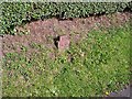
Old GPO telephone cable marker (4), close up
For setting, see Image .
An Edwardian relic, installed by the General Post Office (GPO) to show the location of an underground telephone cable or junction.
For information, see a similar but more exposed specimen below Summer Hill Image .
Image: © Rose and Trev Clough
Taken: 3 Oct 2016
0.10 miles