IMAGES TAKEN NEAR TO
Petteril Bank Road, CARLISLE, CA1 3AP
Introduction
This page details the photographs taken nearby to Petteril Bank Road, CA1 3AP by members of the Geograph project.
The Geograph project started in 2005 with the aim of publishing, organising and preserving representative images for every square kilometre of Great Britain, Ireland and the Isle of Man.

There are currently over 7.5m images from over14,400 individuals and you can help contribute to the project by visiting https://www.geograph.org.uk
Image Map
Images are licensed for reuse under creativecommons.org/licenses/by-sa/2.0
Notes
- Clicking on the map will re-center to the selected point.
- The higher the marker number, the further away the image location is from the centre of the postcode.
Image Listing (41 Images Found)
Images are licensed for reuse under creativecommons.org/licenses/by-sa/2.0
Image
Details
Distance
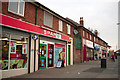
2
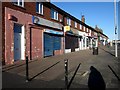
Petteril Bank Post Office
On Petteril Bank Road.
Image: © JThomas
Taken: 10 Oct 2015
0.03 miles
3
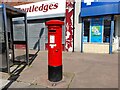
Post Box at Petteril Bank, Carlisle
CA1 370. Royal Mail list this box as Petteril Bank. It bears the Royal cipher of the late King George VI.
Image: © David Bremner
Taken: 15 Jul 2021
0.03 miles
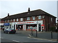
5
Local shops, Petteril Bank Road, Carlisle
A parade of shops serving the local community on Petteril Bank Road, Carlisle.
Image: © Graham Robson
Taken: 3 Nov 2013
0.06 miles
6

Aldi, Petteril Bank Road, Carlisle
An Aldi supermarket accessed off Petteril Bank Road, Carlisle.
Image: © Graham Robson
Taken: 3 Nov 2013
0.06 miles
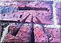
7
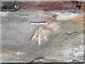
O.S Cut Benchmark at Petteril Bank Road, Carlisle
In good condition on a roadside wall.
Image: © David Bremner
Taken: 10 Jun 2022
0.09 miles
8
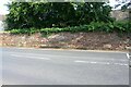
Stone wall on SE side of Petteril Bank Road opposite No. 18
There is an Ordnance Survey benchmark Image on the large rectangular stone in the wall near the right hand edge of the image
Image: © Luke Shaw
Taken: 24 Aug 2019
0.09 miles
9
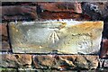
Benchmark on wall on SE side of Petteril Bank Road
Ordnance Survey cut mark benchmark described on the Bench Mark Database at www.bench-marks.org.uk/bm103221
Image: © Luke Shaw
Taken: 24 Aug 2019
0.09 miles
10
Benchmark on side (NW face) of #360 London Road
Ordnance Survey cut mark benchmark levelled at 40.654m above Newlyn Datum verified 1972
Image: © Roger Templeman
Taken: 21 Oct 2021
0.12 miles