IMAGES TAKEN NEAR TO
Lorton, COCKERMOUTH, CA13 9UU
Introduction
This page details the photographs taken nearby to CA13 9UU by members of the Geograph project.
The Geograph project started in 2005 with the aim of publishing, organising and preserving representative images for every square kilometre of Great Britain, Ireland and the Isle of Man.

There are currently over 7.5m images from over14,400 individuals and you can help contribute to the project by visiting https://www.geograph.org.uk
Image Map (Loading...)


Getting Data...Please wait
Leaflet Map data © OpenStreetMap
Images are licensed for reuse under creativecommons.org/licenses/by-sa/2.0
Notes
- Clicking on the map will re-center to the selected point.
- The higher the marker number, the further away the image location is from the centre of the postcode.
Image Listing (8 Images Found)
Images are licensed for reuse under creativecommons.org/licenses/by-sa/2.0
Image
Details
Distance
2
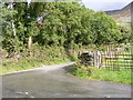
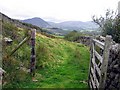
Hopebeck Road Junction
The view from the B5289 Buttermere to Cockermouth road.
Image: © Gordon Griffiths
Taken: 11 Sep 2012
0.18 miles
3
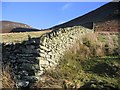
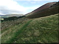
Fell Enclosure.
Dodd is in the clear blue sky to the left.
Image: © John Holmes
Taken: 1 Jan 2006
0.18 miles
4
Hopebeck Sign
The view on the B5289 Buttermere to Cockermouth road.
Image: © Gordon Griffiths
Taken: 11 Sep 2012
0.19 miles
5
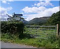
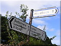
Gated Field at the Hopebeck Road Junction
The signpost seems to have taken a knock since 2012 see: Image
Image: © Anthony Parkes
Taken: 9 Aug 2017
0.20 miles
8
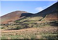
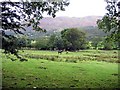
A mixture of farming.
Dodd is the peak on the left.
Image: © John Holmes
Taken: 1 Jan 2006
0.24 miles