IMAGES TAKEN NEAR TO
High Lorton, COCKERMOUTH, CA13 9UL
Introduction
This page details the photographs taken nearby to CA13 9UL by members of the Geograph project.
The Geograph project started in 2005 with the aim of publishing, organising and preserving representative images for every square kilometre of Great Britain, Ireland and the Isle of Man.

There are currently over 7.5m images from over14,400 individuals and you can help contribute to the project by visiting https://www.geograph.org.uk
Image Map
Images are licensed for reuse under creativecommons.org/licenses/by-sa/2.0
Notes
- Clicking on the map will re-center to the selected point.
- The higher the marker number, the further away the image location is from the centre of the postcode.
Image Listing (15 Images Found)
Images are licensed for reuse under creativecommons.org/licenses/by-sa/2.0
Image
Details
Distance

3
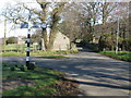
Crossroads in Lorton
Intersection of 2 unclassified roads between Low Lorton and High Lorton. It is always a pleasure to see an old traditional road sign being well maintained.
Image: © G Laird
Taken: 11 Mar 2014
0.12 miles
4
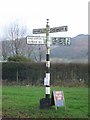
Old Direction Sign - Signpost, Cross Gates, Low Lorton
Pawn finial - 4 arms; Cumberland CC square end by the UC road, in parish of Lorton (Allerdale District), Cross Gates, Lorton, grass verge.
Surveyed
Milestone Society National ID: CU_NY1525A.
Image: © Milestone Society
Taken: Unknown
0.12 miles
5
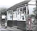
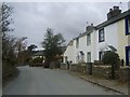
Low Lorton - Post Office
Still the village shop but sadly no longer (2008) the Post Office.
Image: © Paula Goodfellow
Taken: Unknown
0.15 miles
7
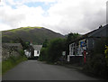
High Lorton
Pleasant village above the River Cocker in Lorton Vale
Image: © Michael Graham
Taken: 28 Feb 2010
0.20 miles
8
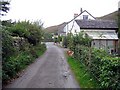
Cottages, Lorton
The three cream coloured cottages are a former brewery. The white cottage is Corner House. A narrow road, the direct route to Whinlatter, goes off to the left between these sets of buildings.
Image: © Andrew Smith
Taken: 31 Oct 2008
0.20 miles
10
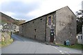
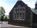
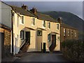
Village Hall, High Lorton
Previously a malting barn, this was donated to the village by the brewery to become the very imposing village hall.
Image: © Trevor Harris
Taken: 27 Oct 2008
0.20 miles