IMAGES TAKEN NEAR TO
Lorton, COCKERMOUTH, CA13 9UE
Introduction
This page details the photographs taken nearby to CA13 9UE by members of the Geograph project.
The Geograph project started in 2005 with the aim of publishing, organising and preserving representative images for every square kilometre of Great Britain, Ireland and the Isle of Man.

There are currently over 7.5m images from over14,400 individuals and you can help contribute to the project by visiting https://www.geograph.org.uk
Image Map
Images are licensed for reuse under creativecommons.org/licenses/by-sa/2.0
Notes
- Clicking on the map will re-center to the selected point.
- The higher the marker number, the further away the image location is from the centre of the postcode.
Image Listing (33 Images Found)
Images are licensed for reuse under creativecommons.org/licenses/by-sa/2.0
Image
Details
Distance
1
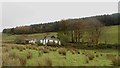
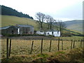
Darling How farm
The isolated dwelling and small farm at Darling How.
Image: © Graham Robson
Taken: 4 Nov 2014
0.02 miles
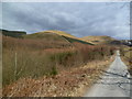
2
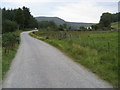
Nearing Darling How
Footpath to Lord's Seat nearing Darling How
Image: © Shaun Ferguson
Taken: 5 Sep 2010
0.03 miles
3
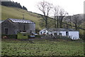
Darling How Farm
In a clearing in Whinlatter Forest
Image: © Bob Jenkins
Taken: 14 Dec 2005
0.03 miles
4
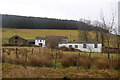
Darling How Farm
Seen from the track below Lorton Fells.
Image: © Trevor Harris
Taken: 23 Feb 2011
0.03 miles
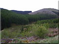
6
In Darling How Plantation
Looking towards Broom Fell
Image: © Michael Graham
Taken: 4 Apr 2013
0.06 miles
7
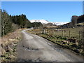
The track to Aiken Plantation
Broom Fell is in the distance ahead.
Image: © David Purchase
Taken: 21 Mar 2013
0.06 miles
8
Darling How Plantation
From the track near Darling How farm
Image: © Michael Graham
Taken: 10 May 2009
0.09 miles
9
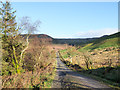
Forest road in valley of Aiken Beck
The road runs alongside Darling How Plantation and is north of an isolated farm, also named Darling How.
Image: © Trevor Littlewood
Taken: 9 Dec 2018
0.11 miles
10
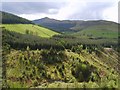
Above Aiken Beck
Near Spout Force looking towards Grisedale Pike
Image: © Michael Graham
Taken: 10 May 2009
0.12 miles