IMAGES TAKEN NEAR TO
Lorton, COCKERMOUTH, CA13 9UD
Introduction
This page details the photographs taken nearby to CA13 9UD by members of the Geograph project.
The Geograph project started in 2005 with the aim of publishing, organising and preserving representative images for every square kilometre of Great Britain, Ireland and the Isle of Man.

There are currently over 7.5m images from over14,400 individuals and you can help contribute to the project by visiting https://www.geograph.org.uk
Image Map
Images are licensed for reuse under creativecommons.org/licenses/by-sa/2.0
Notes
- Clicking on the map will re-center to the selected point.
- The higher the marker number, the further away the image location is from the centre of the postcode.
Image Listing (7 Images Found)
Images are licensed for reuse under creativecommons.org/licenses/by-sa/2.0
Image
Details
Distance
3
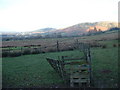
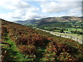
In Lorton Vale
Looking across the fields up Lorton Vale
Image: © Michael Graham
Taken: 11 Dec 2005
0.16 miles
7
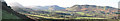
Panorama of Lorton Vale from Above Miller How
On left is Mellbreak (south) Fellbarrow and Whin Fell on right (Northwest). Showing the nature of the southern end of the Vale of Lorton.
Image: © Bob Jenkins
Taken: Unknown
0.22 miles