IMAGES TAKEN NEAR TO
Lorton, COCKERMOUTH, CA13 9TL
Introduction
This page details the photographs taken nearby to CA13 9TL by members of the Geograph project.
The Geograph project started in 2005 with the aim of publishing, organising and preserving representative images for every square kilometre of Great Britain, Ireland and the Isle of Man.

There are currently over 7.5m images from over14,400 individuals and you can help contribute to the project by visiting https://www.geograph.org.uk
Image Map
Images are licensed for reuse under creativecommons.org/licenses/by-sa/2.0
Notes
- Clicking on the map will re-center to the selected point.
- The higher the marker number, the further away the image location is from the centre of the postcode.
Image Listing (5 Images Found)
Images are licensed for reuse under creativecommons.org/licenses/by-sa/2.0
Image
Details
Distance
1

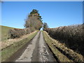
Armaside
Note the road having to go around the end of the building.
Image: © John Holmes
Taken: 18 Nov 2005
0.10 miles

4
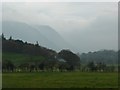
Pasture in Lorton Vale
Grasmoor beyond.
Image: © Russel Wills
Taken: 11 Nov 2011
0.17 miles
5
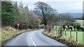
B5292 heading towards Armaside How
Armaside How is a minor feature in the landscape; it's surely in view in the image, probably being the flat, darker green area to the right of the central tree.
Image: © Trevor Littlewood
Taken: 2 Dec 2019
0.25 miles