IMAGES TAKEN NEAR TO
Bewaldeth, COCKERMOUTH, CA13 9SU
Introduction
This page details the photographs taken nearby to CA13 9SU by members of the Geograph project.
The Geograph project started in 2005 with the aim of publishing, organising and preserving representative images for every square kilometre of Great Britain, Ireland and the Isle of Man.

There are currently over 7.5m images from over14,400 individuals and you can help contribute to the project by visiting https://www.geograph.org.uk
Image Map
Images are licensed for reuse under creativecommons.org/licenses/by-sa/2.0
Notes
- Clicking on the map will re-center to the selected point.
- The higher the marker number, the further away the image location is from the centre of the postcode.
Image Listing (5 Images Found)
Images are licensed for reuse under creativecommons.org/licenses/by-sa/2.0
Image
Details
Distance
1
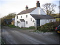
Bewaldeth.
A tiny hamlet with all the houses right on the edge of the minor road.
Image: © John Holmes
Taken: 19 Nov 2005
0.02 miles
2
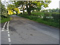
Bewaldeth End Road
Bewaldeth End Road a slip road to the A591
Image: © Shaun Ferguson
Taken: 28 May 2009
0.11 miles
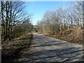
3

Road junction
Junction of the Bewaldeth to Isel Bridge road with the A591
Image: © Alexander P Kapp
Taken: 21 Oct 2007
0.16 miles
4
Road running west from Bewaldeth
Heading towards Isel.
Image: © Christine Johnstone
Taken: 26 Mar 2018
0.20 miles
5
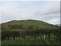
Binsey from the south
Looking up at Binsey from the road.
Image: © T Eyre
Taken: 7 Oct 2018
0.21 miles