IMAGES TAKEN NEAR TO
Bassenthwaite Lake, COCKERMOUTH, CA13 9SH
Introduction
This page details the photographs taken nearby to CA13 9SH by members of the Geograph project.
The Geograph project started in 2005 with the aim of publishing, organising and preserving representative images for every square kilometre of Great Britain, Ireland and the Isle of Man.

There are currently over 7.5m images from over14,400 individuals and you can help contribute to the project by visiting https://www.geograph.org.uk
Image Map
Images are licensed for reuse under creativecommons.org/licenses/by-sa/2.0
Notes
- Clicking on the map will re-center to the selected point.
- The higher the marker number, the further away the image location is from the centre of the postcode.
Image Listing (6 Images Found)
Images are licensed for reuse under creativecommons.org/licenses/by-sa/2.0
Image
Details
Distance
1
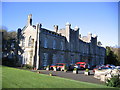
Higham Hall
Used as a training centre and for conferences etc.
Image: © John Holmes
Taken: 17 Nov 2005
0.04 miles
2
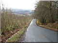
The road to Bassenthwaite
In the distance the snow-covered hill is Binsey, a 447m Wainwright and Marilyn.
Image: © David Purchase
Taken: 19 Mar 2013
0.10 miles
3
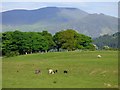
Pasture, Setmurthy
A view towards Skiddaw and Ullock Pike from the road above Higham Hall.
Image: © Andrew Smith
Taken: 26 May 2018
0.20 miles
4
The eastern end of Elva Hill
This spot enables you to look over Big Wood towards Bassenthwaite and Skiddaw.
Image: © Bill Boaden
Taken: 20 Jul 2019
0.22 miles
5
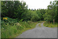
Forestry track into Big Wood
This is private land and there is no public footpath.
Image: © Bill Boaden
Taken: 20 Jul 2019
0.24 miles
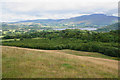
6
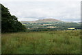
Rough grazing above Setmurthy
A view across the Derwent valley towards Binsey.
Image: © Bill Boaden
Taken: 20 Jul 2019
0.24 miles