IMAGES TAKEN NEAR TO
Ashgrove, COCKERMOUTH, CA13 9RQ
Introduction
This page details the photographs taken nearby to Ashgrove, CA13 9RQ by members of the Geograph project.
The Geograph project started in 2005 with the aim of publishing, organising and preserving representative images for every square kilometre of Great Britain, Ireland and the Isle of Man.

There are currently over 7.5m images from over14,400 individuals and you can help contribute to the project by visiting https://www.geograph.org.uk
Image Map
Images are licensed for reuse under creativecommons.org/licenses/by-sa/2.0
Notes
- Clicking on the map will re-center to the selected point.
- The higher the marker number, the further away the image location is from the centre of the postcode.
Image Listing (349 Images Found)
Images are licensed for reuse under creativecommons.org/licenses/by-sa/2.0
Image
Details
Distance
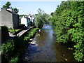
1
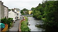
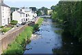
Cockermouth
Looking north, along the River Cocker.
Image: © Peter Trimming
Taken: 7 Jul 2015
0.02 miles
3
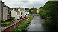
Cockermouth
Looking north along the River Cocker.
Image: © Peter Trimming
Taken: 7 Jul 2015
0.03 miles
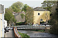
5
The River Cocker flows through Cockermouth
Before joining the River Derwent.
Taken from Victoria Jubilee Bridge which was built by subscription with
the foundation stone being laid in June 1887.
Image: © Russel Wills
Taken: 9 Jun 2018
0.04 miles
6
Cockermouth
River Cocker, from the end of Lorton Street.
Image: © Peter Trimming
Taken: 8 May 2016
0.04 miles
7
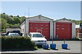
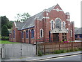
Cockermouth old fire station
Cockermouth old fire station, Lorton Street, Cockermouth, Cumbria, which has been replaced by Image
Image: © Kevin Hale
Taken: 28 May 2010
0.04 miles
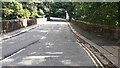
8
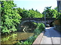
Victoria Jubilee Bridge
The river is the River Cocker and the road Rubby Bank Road
Image: © Alexander P Kapp
Taken: 4 Jun 2007
0.04 miles
9
River Cocker
Looking downstream from Victoria Jubilee Bridge, with Rubby Bank Road on the left
Image: © Alexander P Kapp
Taken: 4 Jun 2007
0.05 miles
10
B5292 crossing River Cocker on Victoria Bridge
Ordnance Survey documents indicate that a benchmark levelled at 51.050m above Newlyn Datum was verified in 1959 on the right hand parapet at its near end
Image: © Roger Templeman
Taken: 24 Aug 2024
0.05 miles