IMAGES TAKEN NEAR TO
South Street, COCKERMOUTH, CA13 9RA
Introduction
This page details the photographs taken nearby to South Street, CA13 9RA by members of the Geograph project.
The Geograph project started in 2005 with the aim of publishing, organising and preserving representative images for every square kilometre of Great Britain, Ireland and the Isle of Man.

There are currently over 7.5m images from over14,400 individuals and you can help contribute to the project by visiting https://www.geograph.org.uk
Image Map
Images are licensed for reuse under creativecommons.org/licenses/by-sa/2.0
Notes
- Clicking on the map will re-center to the selected point.
- The higher the marker number, the further away the image location is from the centre of the postcode.
Image Listing (445 Images Found)
Images are licensed for reuse under creativecommons.org/licenses/by-sa/2.0
Image
Details
Distance
1
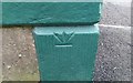
Ordnance Survey Cut Mark
This inverted OS cut mark can be found on No2 Challoner Street. It marks a point 46.390m above mean sea level.
Image: © Adrian Dust
Taken: 27 Mar 2018
0.03 miles
2
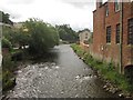
Looking upstream on the River Cocker
Looking upstream from the Main Street bridge over the River Cocker.
Image: © Graham Robson
Taken: 15 Jul 2012
0.04 miles
4
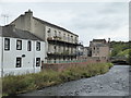
Cockermouth, along the River Cocker
The larger building on the left may have once had an industrial use. I would welcome further information.
Image: © Chris Allen
Taken: 20 Sep 2017
0.05 miles
5
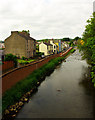
River Cocker flood defences, Cockermouth
For more on the scheme to protect Cockermouth from flooding visit this http://www.environment-agency.gov.uk/homeandleisure/floods/131663.aspx
Image: © Jim Osley
Taken: 26 Jun 2013
0.05 miles
6
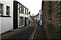
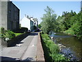
South Street as it narrows down towards the Cocker
Image: © Philip Jeffrey
Taken: 25 Dec 2007
0.05 miles
7

The Cocker looking down to the Main Street Bridge
Image: © Philip Jeffrey
Taken: 25 Dec 2007
0.05 miles
9
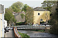
Cockermouth
River Cocker, from the end of Lorton Street.
Image: © Peter Trimming
Taken: 8 May 2016
0.06 miles
10

Riverside Car Park
Beside the River Cocker.
In the far left corner is a stone hut - it's an Environment Agency gauging station for river level monitoring.
Image: © Rose and Trev Clough
Taken: 25 Oct 2014
0.06 miles