IMAGES TAKEN NEAR TO
Lorton Road, COCKERMOUTH, CA13 9PG
Introduction
This page details the photographs taken nearby to Lorton Road, CA13 9PG by members of the Geograph project.
The Geograph project started in 2005 with the aim of publishing, organising and preserving representative images for every square kilometre of Great Britain, Ireland and the Isle of Man.

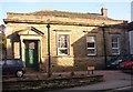
There are currently over 7.5m images from over14,400 individuals and you can help contribute to the project by visiting https://www.geograph.org.uk
Image Map
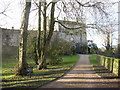
Images are licensed for reuse under creativecommons.org/licenses/by-sa/2.0
Notes
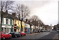
- Clicking on the map will re-center to the selected point.
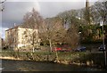
- The higher the marker number, the further away the image location is from the centre of the postcode.
Image Listing (208 Images Found)
Images are licensed for reuse under creativecommons.org/licenses/by-sa/2.0
Image
Details
Distance
1
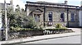
Friends Meeting House on east side of Kirkgate
There is an Ordnance Survey benchmark Image on a stone (second right of BT pole, third above pavement) of the roadside wall
Image: © Roger Templeman
Taken: 24 Aug 2024
0.06 miles
2
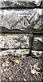
Benchmark on wall on east side of Kirkgate in front of Friends Meeting House
Ordnance Survey cut mark benchmark levelled at 61.500m above Newlyn Datum verified 1969
Image: © Roger Templeman
Taken: 24 Aug 2024
0.06 miles
3
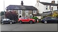
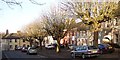
Houses on Fair View
There is an Ordnance Survey benchmark Image on the front of the left hand house at its left hand corner
Image: © Roger Templeman
Taken: 24 Aug 2024
0.07 miles
4
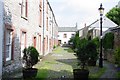
A courtyard, Cockermouth
An old courtyard off Main Street Cockermouth. There are many of these yards, many still retain their original features such as cobbled paths.
Image: © Ann Hodgson
Taken: 7 Jun 2003
0.07 miles
5
Friends' Meeting House, Cockermouth
Quaker meeting houses are of various types, some like cottages and some like chapels. This one, built in 1884, is in a Classical style. It is at NY124305.
Image: © Humphrey Bolton
Taken: 25 Jan 2004
0.07 miles
6
Cockermouth Main Street
The statue is of the 6th Earl of Mayo, an MP for Cockermouth, made in 1875 by W & T Wills of London.
Image: © Humphrey Bolton
Taken: 25 Jan 2004
0.07 miles
7
Cockermouth Castle
This is partly a private house partly in ruins. It was first built in 1134, but after a turbulent history in the Middle Ages during which it was repeatedly destroyed and rebuilt, it passed to the Wyndham family and only the gatehouse, courthouse and some adjacent buildings were maintained. It is at NY122308.
Image: © Humphrey Bolton
Taken: 25 Jan 2004
0.07 miles
8
Town Hall, Cockermouth
Cockermouth Town Hall was built as a Methodist Chapel in 1841. To the right is All Saints' Church, which had been a chapel-of-ease attached to the church at Brigham and became a parish church in 1806.. The present church was built in 1852-4 after the 18C building was destroyed by fire.
Image: © Humphrey Bolton
Taken: Unknown
0.07 miles
9
Kirkgate, Cockermouth
A pleasant street of Georgian houses.
Image: © Humphrey Bolton
Taken: Unknown
0.07 miles
10
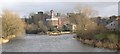
Cockermouth Brewery
Jennings Brewery is the last working factory in Cockermouth, and is sited where the River Cocker joins the River Derwent. Behind is the ruined part of the castle.
Image: © Humphrey Bolton
Taken: Unknown
0.07 miles