IMAGES TAKEN NEAR TO
Main Street, COCKERMOUTH, CA13 9LE
Introduction
This page details the photographs taken nearby to Main Street, CA13 9LE by members of the Geograph project.
The Geograph project started in 2005 with the aim of publishing, organising and preserving representative images for every square kilometre of Great Britain, Ireland and the Isle of Man.

There are currently over 7.5m images from over14,400 individuals and you can help contribute to the project by visiting https://www.geograph.org.uk
Image Map
Images are licensed for reuse under creativecommons.org/licenses/by-sa/2.0
Notes
- Clicking on the map will re-center to the selected point.
- The higher the marker number, the further away the image location is from the centre of the postcode.
Image Listing (483 Images Found)
Images are licensed for reuse under creativecommons.org/licenses/by-sa/2.0
Image
Details
Distance
1
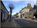
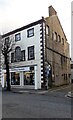
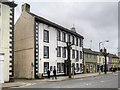
Main Street, Cockermouth
Heading west - note the wording "Fletcher's Fearless Clothing" on the gable wall of Tony Marks Shop
Image: © Kenneth Allen
Taken: 20 Apr 2013
0.00 miles
2
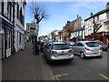
Traffic, Cockermouth
Looking west in Main Street
Image: © Kenneth Allen
Taken: 20 Apr 2013
0.00 miles
3
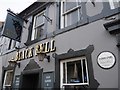
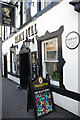
Black Bull Main Street Cockermouth
Cockermouth suffered devastating floods in 2009 when a month's rain fell in 24 hours.The flood waters rose to 2.5 metres/8.2 'and 200 people had to be rescued. Here on the wall of the Black Bull the flood level is marked. Cockermouth has now installed in 2013 the UK's first self-closing flood barriers
Image: © Jennifer Petrie
Taken: 14 Oct 2019
0.00 miles
4
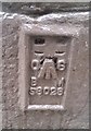
Ordnance Survey Flush Bracket (S8028)
This OS Flush Bracket can be found on No21 Main Street. It marks a point 44.460m above mean sea level.
Image: © Adrian Dust
Taken: 27 Mar 2018
0.01 miles
5
The Children's Society shop, 21 Main Street, at Challoner Street junction
There is an Ordnance Survey benchmark Image on the corner, right hand face, of the building
Image: © Roger Templeman
Taken: 19 Dec 2023
0.01 miles
6
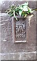
Benchmark on #21 Main Street, Challoner Street face
Ordnance Survey flush bracket, serial identifier S8028, levelled at 44.460m above Newlyn Datum in 1968
Image: © Roger Templeman
Taken: 19 Dec 2023
0.01 miles
7
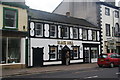
The Black Bull, Cockermouth
There is a plaque by the right hand door which shows the level the flood waters reached in 2009. It is more than head high.
Image: © Bill Boaden
Taken: 29 May 2011
0.01 miles
8
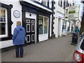
Flood level indicator, Cockermouth
Pictured in Main Street, it is well above head height, as demonstrated by my wife standing under it
See close-up here Image]
Image: © Kenneth Allen
Taken: 20 Apr 2013
0.01 miles
10
The Black Bull, Cockermouth
Note the astonishingly high flood marker on the wall of this Main Street pub, recalling the unprecedented event of November 2009 when this part of the town was flooded to a depth of 2.5 metres.
Image: © Stephen McKay
Taken: 5 Oct 2014
0.01 miles