IMAGES TAKEN NEAR TO
Greyrigg Avenue, COCKERMOUTH, CA13 9EJ
Introduction
This page details the photographs taken nearby to Greyrigg Avenue, CA13 9EJ by members of the Geograph project.
The Geograph project started in 2005 with the aim of publishing, organising and preserving representative images for every square kilometre of Great Britain, Ireland and the Isle of Man.

There are currently over 7.5m images from over14,400 individuals and you can help contribute to the project by visiting https://www.geograph.org.uk
Image Map
Images are licensed for reuse under creativecommons.org/licenses/by-sa/2.0
Notes
- Clicking on the map will re-center to the selected point.
- The higher the marker number, the further away the image location is from the centre of the postcode.
Image Listing (3 Images Found)
Images are licensed for reuse under creativecommons.org/licenses/by-sa/2.0
Image
Details
Distance
1
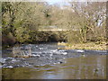
Double Mills Bridge
Opened March 1973, it crosses the River Cocker.
Image: © Bob Jenkins
Taken: 17 Mar 2006
0.16 miles
2
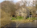
Youth Hostel
Beautifully situated at Double Mills, alongside the River Cocker, near to the centre of the busy but small market town with two breweries, lots of pubs, good food. It's closed - for the winter.
Image: © Bob Jenkins
Taken: 17 Mar 2006
0.23 miles
3
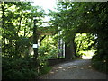
Old railway bridge
This bridge carried the now defunct Cockermouth to Keswick Railway over the River Cocker
Image: © Alexander P Kapp
Taken: 4 Jun 2007
0.23 miles