IMAGES TAKEN NEAR TO
Briar Bank, COCKERMOUTH, CA13 9DN
Introduction
This page details the photographs taken nearby to Briar Bank, CA13 9DN by members of the Geograph project.
The Geograph project started in 2005 with the aim of publishing, organising and preserving representative images for every square kilometre of Great Britain, Ireland and the Isle of Man.

There are currently over 7.5m images from over14,400 individuals and you can help contribute to the project by visiting https://www.geograph.org.uk
Image Map
Images are licensed for reuse under creativecommons.org/licenses/by-sa/2.0
Notes
- Clicking on the map will re-center to the selected point.
- The higher the marker number, the further away the image location is from the centre of the postcode.
Image Listing (7 Images Found)
Images are licensed for reuse under creativecommons.org/licenses/by-sa/2.0
Image
Details
Distance
1
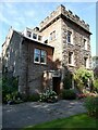
The Towers, Cockermouth
19th Century house, divided into two apartments.
Image: © Oliver Dixon
Taken: 8 Sep 2021
0.13 miles
2
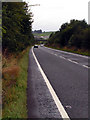
A66, south of Cockermouth
This is the main road linking West Cumbria to the M6
Image: © Nigel Monckton
Taken: 18 Sep 2005
0.15 miles
3
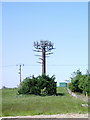
Is it or is it not a tree
Communications mast near Violet Bank camouflaged as a tree
Image: © Alexander P Kapp
Taken: 5 Jun 2007
0.19 miles
4
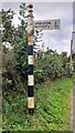
Finger signpost on SW side of B5292 opposite Strawberry How Road
Image is another image of this signpost
Image: © Roger Templeman
Taken: 24 Aug 2024
0.22 miles
5
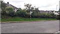
B5292 viewed from west end of Strawberry How Road
There is an old finger signpost Image on the far verge
Image: © Roger Templeman
Taken: 24 Aug 2024
0.22 miles
6
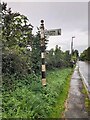
Direction Sign – Signpost on Lorton Road, Cockermouth
Located on the southwest side of the junction of the B5292 Lorton Road and Strawberry How Road in Cockermouth parish. 1 arm and pawn finial.
Milestone Society National ID: CU_NY1229
Image: © B Todd
Taken: 12 Sep 2023
0.23 miles