IMAGES TAKEN NEAR TO
Slatefell Drive, COCKERMOUTH, CA13 9BS
Introduction
This page details the photographs taken nearby to Slatefell Drive, CA13 9BS by members of the Geograph project.
The Geograph project started in 2005 with the aim of publishing, organising and preserving representative images for every square kilometre of Great Britain, Ireland and the Isle of Man.

There are currently over 7.5m images from over14,400 individuals and you can help contribute to the project by visiting https://www.geograph.org.uk
Image Map (Loading...)


Getting Data...Please wait
Leaflet Map data © OpenStreetMap
Images are licensed for reuse under creativecommons.org/licenses/by-sa/2.0
Notes
- Clicking on the map will re-center to the selected point.
- The higher the marker number, the further away the image location is from the centre of the postcode.
Image Listing (12 Images Found)
Images are licensed for reuse under creativecommons.org/licenses/by-sa/2.0
Image
Details
Distance
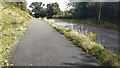
1
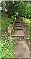
Footpath with steps from south end of Waste Lane
Image: © Luke Shaw
Taken: 24 Aug 2024
0.11 miles
2
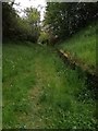
Waste Lane
An old road that led into Cockermouth from Windmill Lane. It is now surrounded by large established housing estates, and comes out on Kirkfell Avenue after a gentle rise uphill. It is a dog walkers route into town and is no longer fit for motorised transport.
Image: © Matthew Hatton
Taken: 19 May 2019
0.12 miles
3
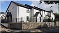
Houses of Pitcairn Close on north side of St Helens Street
Ordnance Survey documents indicate that a benchmark levelled at 53.670m above Newlyn Datum was verified in 1957 'at the junction of houses numbers 76 and 78 St Helens Street' which were houses previously at this location
Image: © Roger Templeman
Taken: 24 Aug 2024
0.17 miles
5
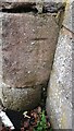
Benchmark on junction of walls on south side of Windmill Lane
Ordnance Survey cut mark benchmark levelled at 65.160m above Newlyn Datum levelled 1969
Image: © Roger Templeman
Taken: 24 Aug 2024
0.21 miles
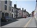
6
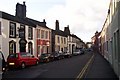
St Helen's Street, Cockermouth
This was the old main road into the town from the east, until it was bypassed some time before 1900. Colour-washed houses and a few pubs.
Image: © Humphrey Bolton
Taken: 25 Jan 2004
0.21 miles
7
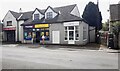
Slatefell Stores on south side of Windmill Lane
There is an Ordnance Survey benchmark Image on the wall junction right of the large stone gatepost and litter bin at the right hand edge of the image
Image: © Roger Templeman
Taken: 24 Aug 2024
0.21 miles
8
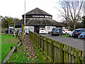
Cockermouth Scout Centre
Also a venue for other clubs and activities.
Image: © Rose and Trev Clough
Taken: 25 Oct 2014
0.21 miles
9
Footpath on northwest side of St Helens Street
Image: © Roger Templeman
Taken: 24 Aug 2024
0.23 miles
10
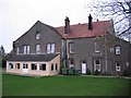
Wyndham House
A school when built now part of a caravan park.
Image: © John Holmes
Taken: 14 Nov 2005
0.23 miles