IMAGES TAKEN NEAR TO
Ennerdale Close, COCKERMOUTH, CA13 9BN
Introduction
This page details the photographs taken nearby to Ennerdale Close, CA13 9BN by members of the Geograph project.
The Geograph project started in 2005 with the aim of publishing, organising and preserving representative images for every square kilometre of Great Britain, Ireland and the Isle of Man.

There are currently over 7.5m images from over14,400 individuals and you can help contribute to the project by visiting https://www.geograph.org.uk
Image Map
Images are licensed for reuse under creativecommons.org/licenses/by-sa/2.0
Notes
- Clicking on the map will re-center to the selected point.
- The higher the marker number, the further away the image location is from the centre of the postcode.
Image Listing (7 Images Found)
Images are licensed for reuse under creativecommons.org/licenses/by-sa/2.0
Image
Details
Distance
1
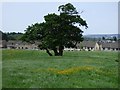
Pasture, Cockermouth
Looking towards houses on Bellbrigg Lonning from the footpath to their east.
Image: © Andrew Smith
Taken: 26 May 2018
0.16 miles
2
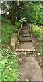
Footpath with steps from south end of Waste Lane
Image: © Luke Shaw
Taken: 24 Aug 2024
0.18 miles
3
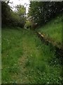
Waste Lane
An old road that led into Cockermouth from Windmill Lane. It is now surrounded by large established housing estates, and comes out on Kirkfell Avenue after a gentle rise uphill. It is a dog walkers route into town and is no longer fit for motorised transport.
Image: © Matthew Hatton
Taken: 19 May 2019
0.18 miles
5
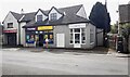
Slatefell Stores on south side of Windmill Lane
There is an Ordnance Survey benchmark Image on the wall junction right of the large stone gatepost and litter bin at the right hand edge of the image
Image: © Roger Templeman
Taken: 24 Aug 2024
0.21 miles
6
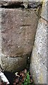
Benchmark on junction of walls on south side of Windmill Lane
Ordnance Survey cut mark benchmark levelled at 65.160m above Newlyn Datum levelled 1969
Image: © Roger Templeman
Taken: 24 Aug 2024
0.21 miles
7
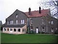
Wyndham House
A school when built now part of a caravan park.
Image: © John Holmes
Taken: 14 Nov 2005
0.24 miles