IMAGES TAKEN NEAR TO
Overend Road, COCKERMOUTH, CA13 0UA
Introduction
This page details the photographs taken nearby to Overend Road, CA13 0UA by members of the Geograph project.
The Geograph project started in 2005 with the aim of publishing, organising and preserving representative images for every square kilometre of Great Britain, Ireland and the Isle of Man.

There are currently over 7.5m images from over14,400 individuals and you can help contribute to the project by visiting https://www.geograph.org.uk
Image Map
Images are licensed for reuse under creativecommons.org/licenses/by-sa/2.0
Notes
- Clicking on the map will re-center to the selected point.
- The higher the marker number, the further away the image location is from the centre of the postcode.
Image Listing (7 Images Found)
Images are licensed for reuse under creativecommons.org/licenses/by-sa/2.0
Image
Details
Distance
1
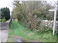
Start of Footpath to Brigham
Known as the 'Foot Trods' this path links Greysouthen to Brigham. A very interesting walk.
Image: © David Hardie
Taken: 9 Oct 2011
0.04 miles
2
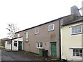
Former Wesleyan Methodist Chapel, Greysouthen
This building, now a house, is a former Wesleyan Methodist Chapel. The street the building is on, Chapel Terrace, takes its name from the building. An inscription above the door dates the chapel to 1833.
Image: © Graham Robson
Taken: 6 Nov 2014
0.12 miles
4
Private Entrance to Tarn Bank
This mansion has a manicured lawn and drive giving it a well looked after feel.
Image: © John Holmes
Taken: 16 Nov 2005
0.16 miles
5
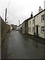
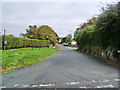
Main Street, Greysouthen
The main street through the small village of Greysouthen.
Image: © Graham Robson
Taken: 6 Nov 2014
0.19 miles
6
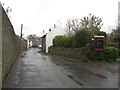
Phone box in Greysouthen
The public telephone box in the small village of Greysouthen is located on the corner of Main Street and Silecroft.
Image: © Graham Robson
Taken: 6 Nov 2014
0.21 miles
7
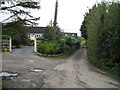
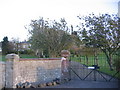
Lonning from Town Head Farm
Looking west down the lonning from Town Head farm, Greysouthen. A bit overgrown, this leads down to the road to Bridgefoot.
Image: © David Hardie
Taken: 9 Oct 2011
0.21 miles