IMAGES TAKEN NEAR TO
Mosser, COCKERMOUTH, CA13 0SR
Introduction
This page details the photographs taken nearby to CA13 0SR by members of the Geograph project.
The Geograph project started in 2005 with the aim of publishing, organising and preserving representative images for every square kilometre of Great Britain, Ireland and the Isle of Man.

There are currently over 7.5m images from over14,400 individuals and you can help contribute to the project by visiting https://www.geograph.org.uk
Image Map
Images are licensed for reuse under creativecommons.org/licenses/by-sa/2.0
Notes
- Clicking on the map will re-center to the selected point.
- The higher the marker number, the further away the image location is from the centre of the postcode.
Image Listing (3 Images Found)
Images are licensed for reuse under creativecommons.org/licenses/by-sa/2.0
Image
Details
Distance
1
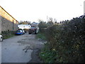
Mosser Mains.
The farm is Mosser Mains and the tractor is spreading muck on the fields.
Image: © John Holmes
Taken: 18 Nov 2005
0.04 miles
2
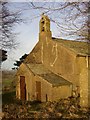
St Michael's Church, Mosser, porch and belfry
This church was built in 1773, the year before Mosser became an ecclesiastical parish, being previously a chapelry of Brigham. The church is confusingly also referred to as St Philip's, eg in The National Gazetteer of Great Britain and Ireland (1868).
Image: © Humphrey Bolton
Taken: 2 Jan 2004
0.19 miles
3
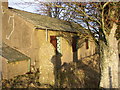
St Michael's Church, Mosser, view of the south side
This church was built in 1773 on a medieval site and was restored in 1925. The king-post roof trusses are probably 16C and from the earlier church. The font bowl is 12C.
Image: © Humphrey Bolton
Taken: 2 Jan 2004
0.19 miles