IMAGES TAKEN NEAR TO
Low Lorton, COCKERMOUTH, CA13 0RQ
Introduction
This page details the photographs taken nearby to CA13 0RQ by members of the Geograph project.
The Geograph project started in 2005 with the aim of publishing, organising and preserving representative images for every square kilometre of Great Britain, Ireland and the Isle of Man.

There are currently over 7.5m images from over14,400 individuals and you can help contribute to the project by visiting https://www.geograph.org.uk
Image Map
Images are licensed for reuse under creativecommons.org/licenses/by-sa/2.0
Notes
- Clicking on the map will re-center to the selected point.
- The higher the marker number, the further away the image location is from the centre of the postcode.
Image Listing (9 Images Found)
Images are licensed for reuse under creativecommons.org/licenses/by-sa/2.0
Image
Details
Distance
1
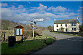
Hedge and Old Fence Post
From the Whinfell Hall camping ground.
Image: © Mick Garratt
Taken: 25 Apr 2009
0.06 miles
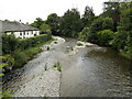
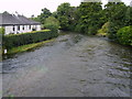
5
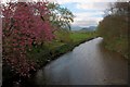
River Cocker
Looking upstream from the bridge.
Image: © Mick Garratt
Taken: 26 Apr 2009
0.16 miles
6
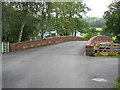
Lorton Low Bridge
Lorton Low Bridge was swept away in the floods of November 2009. It was a twin-arched stone bridge with a central pier in the river, and was Grade II listed. Almost exactly a year ago, I took a photo of the construction works for the new bridge - see Image (Note that that photo is facing in the opposite direction.)
Now this fine new bridge is in place. For obvious reasons no attempt was made to follow the original design, but this single arch span should present little obstruction to any future floods, and so (I hope) ensure its survival for many years to come.
Image: © David Purchase
Taken: 9 Sep 2011
0.18 miles
7
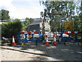
Lorton Low Bridge
This bridge was swept away in the November 2009 floods and a new bridge is seen under construction. Until complete, some journeys in the area require quite long detours.
As far as I can see, there is no photo of the former bridge (a twin-arched stone bridge with a central pier in the river, which was Grade II listed) on the Geograph site. A pity!
The completed new bridge can be seen in Image
Image: © David Purchase
Taken: 8 Sep 2010
0.19 miles
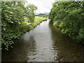
8
River Cocker
From the bridge at Low Lorton
Image: © Michael Graham
Taken: 7 Sep 2008
0.19 miles