IMAGES TAKEN NEAR TO
Isel, COCKERMOUTH, CA13 0QG
Introduction
This page details the photographs taken nearby to CA13 0QG by members of the Geograph project.
The Geograph project started in 2005 with the aim of publishing, organising and preserving representative images for every square kilometre of Great Britain, Ireland and the Isle of Man.

There are currently over 7.5m images from over14,400 individuals and you can help contribute to the project by visiting https://www.geograph.org.uk
Image Map
Images are licensed for reuse under creativecommons.org/licenses/by-sa/2.0
Notes
- Clicking on the map will re-center to the selected point.
- The higher the marker number, the further away the image location is from the centre of the postcode.
Image Listing (8 Images Found)
Images are licensed for reuse under creativecommons.org/licenses/by-sa/2.0
Image
Details
Distance
1
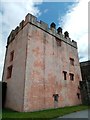
Isel Hall - Pele Tower
14th century pele tower at Isel Hall - a Grade I listed building https://co-curate.ncl.ac.uk/isel-hall/
Image: © Simon Cotterill
Taken: 29 Jul 2019
0.04 miles
2
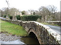
Isel Hall, and the bridge over Blumer Beck
Image: © David Purchase
Taken: 19 Mar 2013
0.10 miles
3
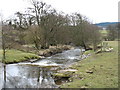
Blumer Beck
Taken from the minor road bridge near Isel Hall, and looking downstream. Blumer Beck flows into the River Derwent in about 100 metres.
Image: © David Purchase
Taken: 19 Mar 2013
0.14 miles
4
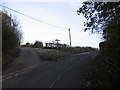
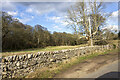
Minor road junction to Park Wood.
Small triangle of grass around the signpost lets vehicles pass either side.
Image: © John Holmes
Taken: 19 Nov 2005
0.15 miles
5
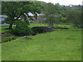
Mill Bridge over Blumer Beck
The buildings beyond the bridge are those of Isel Corn Mill, built in the mid 19thC and now Grade II Listed. They are now used as a farm.
Image: © Matthew Hatton
Taken: 23 May 2014
0.15 miles
6
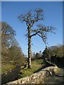
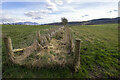
Stream Emerging from Park Wood
This stream gurgles along and under the bridge.
Image: © Alison Rawson
Taken: 16 Feb 2008
0.16 miles