IMAGES TAKEN NEAR TO
Tallentire, COCKERMOUTH, CA13 0PY
Introduction
This page details the photographs taken nearby to CA13 0PY by members of the Geograph project.
The Geograph project started in 2005 with the aim of publishing, organising and preserving representative images for every square kilometre of Great Britain, Ireland and the Isle of Man.

There are currently over 7.5m images from over14,400 individuals and you can help contribute to the project by visiting https://www.geograph.org.uk
Image Map
Images are licensed for reuse under creativecommons.org/licenses/by-sa/2.0
Notes
- Clicking on the map will re-center to the selected point.
- The higher the marker number, the further away the image location is from the centre of the postcode.
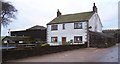
Image Listing (4 Images Found)
Images are licensed for reuse under creativecommons.org/licenses/by-sa/2.0
Image
Details
Distance
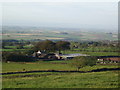
2
Hill Farm.
Previously known as Tallentire Hill Farm
Image: © John Holmes
Taken: 26 Dec 2005
0.05 miles
4
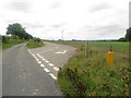
Windfarm access road
An access track leaving the country road east of Tallentire which provides access to the turbines of Tallentire Wind Farm.
Image: © Graham Robson
Taken: 17 Jun 2016
0.23 miles