IMAGES TAKEN NEAR TO
Bridekirk, COCKERMOUTH, CA13 0PB
Introduction
This page details the photographs taken nearby to CA13 0PB by members of the Geograph project.
The Geograph project started in 2005 with the aim of publishing, organising and preserving representative images for every square kilometre of Great Britain, Ireland and the Isle of Man.

There are currently over 7.5m images from over14,400 individuals and you can help contribute to the project by visiting https://www.geograph.org.uk
Image Map
Images are licensed for reuse under creativecommons.org/licenses/by-sa/2.0
Notes
- Clicking on the map will re-center to the selected point.
- The higher the marker number, the further away the image location is from the centre of the postcode.
Image Listing (8 Images Found)
Images are licensed for reuse under creativecommons.org/licenses/by-sa/2.0
Image
Details
Distance
1
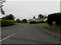
Housing estate, Bridekirk
A small housing development off the main road through the village.
Image: © Graham Robson
Taken: 17 Jun 2016
0.02 miles
2
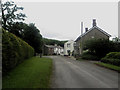
Road through Bridekirk
The road through Bridekirk, most of the houses in the village line this road.
Image: © Graham Robson
Taken: 17 Jun 2016
0.05 miles
3
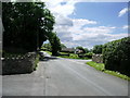
Crossroads
south side of Bridekirk the road to the right goes back to Cockermouth
Image: © Alexander P Kapp
Taken: 19 Jun 2007
0.08 miles
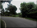
4

2 exits from Bridekirk.
The larger of the 2 roads going around the bend has priority but a tricky junction I think.
Image: © John Holmes
Taken: 19 Nov 2005
0.13 miles
5
Road junction south of Bridekirk
A road junction between minor roads on a bend to the south of Bridekirk village.
Image: © Graham Robson
Taken: 17 Jun 2016
0.13 miles
6

Road junction in Bridekirk
A road junction in Bridekirk where the road to the left leads towards Dovenby.
Image: © Graham Robson
Taken: 17 Jun 2016
0.15 miles
7

Post box, Bridekirk
A wall box located in a garden wall in the middle of Bridekirk.
Image: © Graham Robson
Taken: 17 Jun 2016
0.16 miles
8
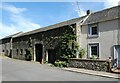
Old barn at the northern end of Bridekirk village
Image: © Oliver Dixon
Taken: 8 Sep 2021
0.24 miles