IMAGES TAKEN NEAR TO
Papcastle, COCKERMOUTH, CA13 0JU
Introduction
This page details the photographs taken nearby to CA13 0JU by members of the Geograph project.
The Geograph project started in 2005 with the aim of publishing, organising and preserving representative images for every square kilometre of Great Britain, Ireland and the Isle of Man.

There are currently over 7.5m images from over14,400 individuals and you can help contribute to the project by visiting https://www.geograph.org.uk
Image Map
Images are licensed for reuse under creativecommons.org/licenses/by-sa/2.0
Notes
- Clicking on the map will re-center to the selected point.
- The higher the marker number, the further away the image location is from the centre of the postcode.
Image Listing (13 Images Found)
Images are licensed for reuse under creativecommons.org/licenses/by-sa/2.0
Image
Details
Distance
1
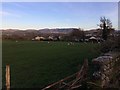
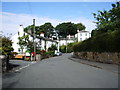
Papcastle view
View of Grasmoor from Papcastle near Cockermouth.
Image: © Richard Thomas
Taken: 2 Apr 2017
0.07 miles
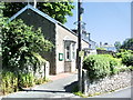
2
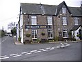
The Belle Vue Public House
Meals are first class.
Image: © John Holmes
Taken: 14 Nov 2005
0.07 miles
3
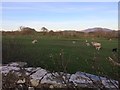
Sheep at Papcastle
Sheep at Papcastle village near Cockermouth.
Image: © Richard Thomas
Taken: 2 Apr 2017
0.12 miles
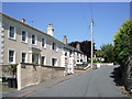
4
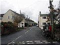
Residential cul-de-sac, Papcastle
A short residential street in Papcastle.
Image: © Graham Robson
Taken: 6 Nov 2013
0.14 miles
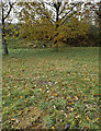
8

Papcastle farmland, Cockermouth and Grasmoor
Looking southeast from Papcastle across the River Derwent to Cockermouth and Grasmoor.
Image: © Richard Thomas
Taken: 16 Nov 2014
0.22 miles
9
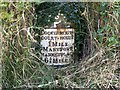
Old Milestone by the A5086, east of Papcastle
Metal plate attached to stone post by the A5086, in parish of PAPCASTLE (ALLERDALE District), Belle Vue, Papcastle roundabout, in bank behind young oak trees, on South side of road. Carlisle red stone & curved plate, erected by the Cockermouth & Maryport turnpike trust in the 19th century.
Inscription reads:-
COCKERMOUTH
COURT-HOUSE
1 MILE
MARYPORT
MARKET-PLACE
6¼ MILES
Grade II Listed. List Entry Number: 1138138
https://historicengland.org.uk/listing/the-list/list-entry/1138138
Milestone Society National ID: CU_CMMP01.
Image: © CF Smith
Taken: 23 Oct 2007
0.22 miles
10
Old Milestone by the A5086, east of Papcastle
Metal plate attached to stone post by the A5086, in parish of PAPCASTLE (ALLERDALE District), Belle Vue, Papcastle roundabout, in bank behind young oak trees, on South side of road. Carlisle red stone & curved plate, erected by the Cockermouth & Maryport turnpike trust in the 19th century.
Inscription reads:-
COCKERMOUTH
COURT-HOUSE
1 MILE
MARYPORT
MARKET-PLACE
6¼ MILES
Grade II Listed. List Entry Number: 1138138
https://historicengland.org.uk/listing/the-list/list-entry/1138138
Milestone Society National ID: CU_CMMP01.
Image: © Barbara Todd
Taken: 9 Nov 2023
0.22 miles