IMAGES TAKEN NEAR TO
Rubby Banks Road, COCKERMOUTH, CA13 0DT
Introduction
This page details the photographs taken nearby to Rubby Banks Road, CA13 0DT by members of the Geograph project.
The Geograph project started in 2005 with the aim of publishing, organising and preserving representative images for every square kilometre of Great Britain, Ireland and the Isle of Man.

There are currently over 7.5m images from over14,400 individuals and you can help contribute to the project by visiting https://www.geograph.org.uk
Image Map
Images are licensed for reuse under creativecommons.org/licenses/by-sa/2.0
Notes
- Clicking on the map will re-center to the selected point.
- The higher the marker number, the further away the image location is from the centre of the postcode.
Image Listing (40 Images Found)
Images are licensed for reuse under creativecommons.org/licenses/by-sa/2.0
Image
Details
Distance
1
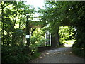
Old railway bridge
This bridge carried the now defunct Cockermouth to Keswick Railway over the River Cocker
Image: © Alexander P Kapp
Taken: 4 Jun 2007
0.07 miles
2
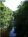
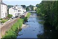
River Cocker
Looking upstream from Victoria Jubilee Bridge
Image: © Alexander P Kapp
Taken: 4 Jun 2007
0.10 miles
3
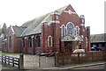
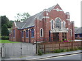
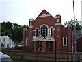
Methodist Chapel, Cockermouth
This large brick chapel is in Lorton Street.
Image: © Humphrey Bolton
Taken: 25 Jan 2004
0.11 miles
4
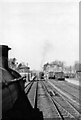
View from locomotive cab on approach to Cockermouth station, 1953
View eastward, towards Keswick and Penrith on a train from Workington to Penrith on the ex-LNWR line, closed from 18/4/66. The locomotive is LMS Ivatt 2MT 2-6-0 No. 46491 (built 12/51, withdrawn 5/67); approaching on a westbound train is another of the same class.
Image: © Walter Dendy, deceased
Taken: 24 Mar 1953
0.11 miles
5
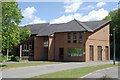
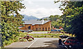
Cumbria Fire & Rescue Service Headquarters
Cumbria Fire & Rescue Service HQ, Station Road, Cockermouth, Cumbria
Image: © Kevin Hale
Taken: 28 May 2010
0.14 miles
7
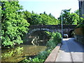
Victoria Jubilee Bridge
The river is the River Cocker and the road Rubby Bank Road
Image: © Alexander P Kapp
Taken: 4 Jun 2007
0.15 miles
8
Site of Cockermouth station, 1986
View eastward, towards Penrith: ex-LNW (Workington, Cockermouth, Keswick & Penrith section). The station, and the line between Keswick and Workington, had been closed from 18/4/66 - and obviously now 20 years later had been redeveloped. The rest of this route - the only effective rail access to the Lake District - was closed from 8/9/72, and considerable stretches were used to 'improve' the A66 trunk road. The mountain in the distance is Skiddaw (3,054 ft.).
Image: © Ben Brooksbank
Taken: 8 Jul 1986
0.15 miles
9
The River Cocker flows through Cockermouth
Before joining the River Derwent.
Taken from Victoria Jubilee Bridge which was built by subscription with
the foundation stone being laid in June 1887.
Image: © Russel Wills
Taken: 9 Jun 2018
0.15 miles