IMAGES TAKEN NEAR TO
The Close, Henry Street, COCKERMOUTH, CA13 0AS
Introduction
This page details the photographs taken nearby to The Close, Henry Street, CA13 0AS by members of the Geograph project.
The Geograph project started in 2005 with the aim of publishing, organising and preserving representative images for every square kilometre of Great Britain, Ireland and the Isle of Man.

There are currently over 7.5m images from over14,400 individuals and you can help contribute to the project by visiting https://www.geograph.org.uk
Image Map (Loading...)


Getting Data...Please wait
Leaflet Map data © OpenStreetMap
Images are licensed for reuse under creativecommons.org/licenses/by-sa/2.0
Notes
- Clicking on the map will re-center to the selected point.
- The higher the marker number, the further away the image location is from the centre of the postcode.
Image Listing (17 Images Found)
Images are licensed for reuse under creativecommons.org/licenses/by-sa/2.0
Image
Details
Distance
1
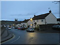
Lamplugh Road, Cockermouth
Lamplugh Road, or the A5086.
Image: © Graham Robson
Taken: 6 Nov 2014
0.10 miles
2
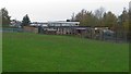
St Joseph's Catholic Primary School, Cockermouth
The site and buildings of St Joseph's Catholic Primary School viewed from The Level.
Image: © Graham Robson
Taken: 6 Nov 2014
0.16 miles
3
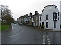
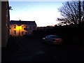
Sullart Street, Cockermouth
Houses on Sullart Street in the Cumbrian town of Cockermouth. This image was taken at dusk on a late November day.
Image: © Malc McDonald
Taken: 26 Nov 2022
0.17 miles
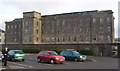
4
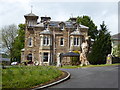
Once a Mental Hospital, now converted to an Old People's Home
Image: © Sarah Charlesworth
Taken: 21 May 2016
0.18 miles
5
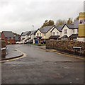
Woodville Park, Cockermouth
New housing estate, Woodville Park, just off Sullart Street, Cockermouth.
Image: © Richard Thomas
Taken: 27 Oct 2014
0.19 miles
6
Derwent Mill, Cockermouth
Derwent Mills, built to manufacture embroidery thread in 1837-55, a business that lasted until the 1930s. The mills later became a shoe factory, which closed in the 1990s, and is now converted to flats. At NY118309.
Image: © Humphrey Bolton
Taken: Unknown
0.20 miles
7
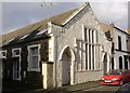
Former Chapel, New Street, Cockermouth
Tucked away up a side street off Crown Street, this chapel has been converted into a row of cottages. The window (partly blocked) facing the street is unusual.
Image: © Humphrey Bolton
Taken: Unknown
0.20 miles
8
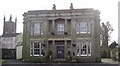
Grecian Villa, Crown Street, Cockermouth
This house, built c.1830, was rated by Nikolaus Pevsner as one of the two best in the town. The appearance is now rather spoilt by the expanse of tarmac car-park in front of it. The Christ Church (built in 1865) is in the background.
Image: © Humphrey Bolton
Taken: 25 Jan 2004
0.20 miles
9
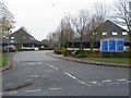
Lakeland Business Park, Lamplugh Road, Cockermouth
A small business park on the southern outskirts of Cockermouth. It consists of offices and is occupied by a variety of organisations.
Image: © Graham Robson
Taken: 6 Nov 2014
0.21 miles
10
Fletcher Street east, Cockermouth
The eastern side of Fletcher Street, Cockermouth. The houses at the end of the road are actually 37-39 Derwent Street.
Image: © Richard Thomas
Taken: 16 Jan 2012
0.22 miles