IMAGES TAKEN NEAR TO
Newlands Road, COCKERMOUTH, CA13 0AH
Introduction
This page details the photographs taken nearby to Newlands Road, CA13 0AH by members of the Geograph project.
The Geograph project started in 2005 with the aim of publishing, organising and preserving representative images for every square kilometre of Great Britain, Ireland and the Isle of Man.

There are currently over 7.5m images from over14,400 individuals and you can help contribute to the project by visiting https://www.geograph.org.uk
Image Map (Loading...)


Getting Data...Please wait
Leaflet Map data © OpenStreetMap
Images are licensed for reuse under creativecommons.org/licenses/by-sa/2.0
Notes
- Clicking on the map will re-center to the selected point.
- The higher the marker number, the further away the image location is from the centre of the postcode.
Image Listing (78 Images Found)
Images are licensed for reuse under creativecommons.org/licenses/by-sa/2.0
Image
Details
Distance
1
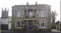
Grecian Villa, Crown Street, Cockermouth
This house, built c.1830, was rated by Nikolaus Pevsner as one of the two best in the town. The appearance is now rather spoilt by the expanse of tarmac car-park in front of it. The Christ Church (built in 1865) is in the background.
Image: © Humphrey Bolton
Taken: 25 Jan 2004
0.02 miles
2
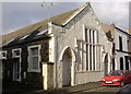
Former Chapel, New Street, Cockermouth
Tucked away up a side street off Crown Street, this chapel has been converted into a row of cottages. The window (partly blocked) facing the street is unusual.
Image: © Humphrey Bolton
Taken: Unknown
0.02 miles
3
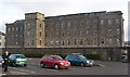
Derwent Mill, Cockermouth
Derwent Mills, built to manufacture embroidery thread in 1837-55, a business that lasted until the 1930s. The mills later became a shoe factory, which closed in the 1990s, and is now converted to flats. At NY118309.
Image: © Humphrey Bolton
Taken: Unknown
0.02 miles
4
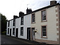
Fletcher Street west, Cockermouth
The western side of Fletcher Street, Cockermouth. House numbers 2-8. The road becomes Fletcher Close beyond these houses.
Image: © Richard Thomas
Taken: 3 Jun 2013
0.06 miles
5
Fletcher Street east, Cockermouth
The eastern side of Fletcher Street, Cockermouth. The houses at the end of the road are actually 37-39 Derwent Street.
Image: © Richard Thomas
Taken: 16 Jan 2012
0.09 miles
6
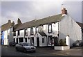
Kingfisher Inn, Cockermouth
One of the old coaching inns of Cockermouth, in Crown Street near to Derwent Bridge.
Image: © Humphrey Bolton
Taken: 25 Jan 2004
0.13 miles
7
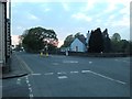
Gote Bridge roundabout, Cockermouth
The mini roundabout on the south side of Gote Bridge which crosses the River Derwent in Cockermouth. This is the junction between Low Road, Crown Street, Gote Road, Derwent Street and Horsman Street.
Image: © Richard Thomas
Taken: 29 Apr 2014
0.14 miles
8
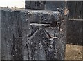
Ordnance Survey Cut Mark
This OS cut mark can be found on No28 Crown Street. It marks a point 46.205m above mean sea level.
Image: © Adrian Dust
Taken: 27 Mar 2018
0.15 miles
9
Benchmark on Gote Bridge
Detail of the Ordnance Survey flush bracket benchmark number S0206 on the east parapet of Gote Bridge. The benchmark marks a height of 45.6434m above sea level (Ordnance Datum Newlyn) and was last levelled in 1954 and verified in 1968 (location photograph Image).
Image: © Adrian Taylor
Taken: 21 Jul 2021
0.16 miles
10
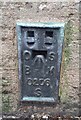
Ordnance Survey Flush Bracket (S0206)
This OS Flush Bracket can be found on the east parapet of Derwent Bridge. It marks a point 45.643m above mean sea level.
Image: © Adrian Dust
Taken: 27 Mar 2018
0.16 miles