IMAGES TAKEN NEAR TO
Scotby Gardens, CARLISLE, CA1 2XH
Introduction
This page details the photographs taken nearby to Scotby Gardens, CA1 2XH by members of the Geograph project.
The Geograph project started in 2005 with the aim of publishing, organising and preserving representative images for every square kilometre of Great Britain, Ireland and the Isle of Man.

There are currently over 7.5m images from over14,400 individuals and you can help contribute to the project by visiting https://www.geograph.org.uk
Image Map
Images are licensed for reuse under creativecommons.org/licenses/by-sa/2.0
Notes
- Clicking on the map will re-center to the selected point.
- The higher the marker number, the further away the image location is from the centre of the postcode.
Image Listing (38 Images Found)
Images are licensed for reuse under creativecommons.org/licenses/by-sa/2.0
Image
Details
Distance
1
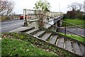
Bridge taking Eastern Way over Durranhill Road
There is an OS benchmark Image on top of the concrete parapet close to its near end
Image: © Luke Shaw
Taken: 16 Nov 2019
0.03 miles
3
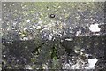
Benchmark on NW parapet of Eastern Way bridge
Ordnance Survey rivet benchmark described on the Bench Mark Database at www.bench-marks.org.uk/bm113312
Image: © Luke Shaw
Taken: 16 Nov 2019
0.05 miles
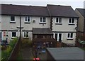
4
Holywell Crescent, Carlisle
Looking along a residential street seen from Eastern Way.
Image: © Graham Robson
Taken: 3 Nov 2013
0.06 miles
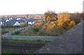
5
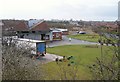
Botcherby Dairy
Viewed from Durranhill Bridge - the entrance is in Holywell Crescent (right). For many years this was a Co-op dairy. It was acquired by Dairy Farmers of Britain http://en.wikipedia.org/wiki/Dairy_Farmers_of_Britain in 2004, and was used as a milk distribution depot until the farmers' co-operative collapsed in June 2009.
Most of the buildings were demolished in the second half of 2010.
Image: © Rose and Trev Clough
Taken: 1 Mar 2008
0.07 miles
6
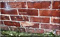
Benchmark on 88 Durranhill Road
Ordnance Survey cut mark benchmark described on the Bench Mark Database at www.bench-marks.org.uk/bm113313
Image: © Luke Shaw
Taken: 16 Nov 2019
0.07 miles
7
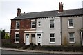
Durranhill Road houses
There is an OS benchmark Image on the front of the left hand house near the abutting brick wall
Image: © Luke Shaw
Taken: 16 Nov 2019
0.07 miles
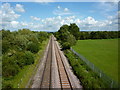
9
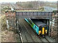
Train passing under disused bridge
The Carlisle to Newcastle line at Durranhill. For more information, see Image .
Image: © Rose and Trev Clough
Taken: 1 Mar 2008
0.08 miles
10
View over western parapet of Durranhill Bridge (Eastern Way)
The embankment in the middle ground carried a railway bridge which was demolished when Eastern Way was completed. There was an Ordnance Survey benchmark on the parapet of the old bridge: see www.bench-marks.org.uk/bm113439
Image: © Luke Shaw
Taken: 18 Nov 2019
0.08 miles