IMAGES TAKEN NEAR TO
Whimbrel Drive, CARLISLE, CA1 2WG
Introduction
This page details the photographs taken nearby to Whimbrel Drive, CA1 2WG by members of the Geograph project.
The Geograph project started in 2005 with the aim of publishing, organising and preserving representative images for every square kilometre of Great Britain, Ireland and the Isle of Man.

There are currently over 7.5m images from over14,400 individuals and you can help contribute to the project by visiting https://www.geograph.org.uk
Image Map
Images are licensed for reuse under creativecommons.org/licenses/by-sa/2.0
Notes
- Clicking on the map will re-center to the selected point.
- The higher the marker number, the further away the image location is from the centre of the postcode.
Image Listing (36 Images Found)
Images are licensed for reuse under creativecommons.org/licenses/by-sa/2.0
Image
Details
Distance
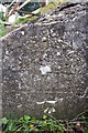
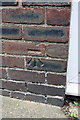
1
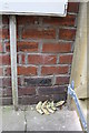
Benchmark on side of #124 Botcherby Avenue
Ordnance Survey cut mark benchmark described on the Bench Mark Database at http://www.bench-marks.org.uk/bm38290
Image: © Roger Templeman
Taken: 12 Jun 2011
0.05 miles
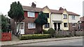
2
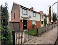
Nos.124-118 (evens) Botcherby Avenue
There is an Ordnance Survey benchmark Image on the side of the nearest house just through the wooden gate
Image: © Roger Templeman
Taken: 16 Oct 2021
0.05 miles
4
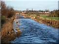
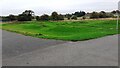
River Petteril flowing through Melbourne Park
View downstream from footbridge towards Botcherby Bridge. The houses are on Warwick Road.
The course of the river here was altered during the late 1950s, it previously ran quite close to properties on Greystone Road. These were liable to flood, so a new straight channel was cut through the park (information from 'Linton Holme - a suburb of Carlisle' by MK Dickens, P3 Publications, 1999).
Image: © Rose and Trev Clough
Taken: 16 Jan 2008
0.11 miles
6
Benchmark on footbridge support in Botcherby Recreation Ground
Ordnance Survey cut mark benchmark described on the Bench Mark Database at http://www.bench-marks.org.uk/bm38291
Image: © Roger Templeman
Taken: 12 Jun 2011
0.13 miles
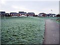
7
Footbridge in Botcherby Recreation Ground
There is an OS benchmark on the RHS support: see Image
Image: © Roger Templeman
Taken: 12 Jun 2011
0.13 miles
8
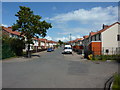
Nos. 65-71 (odds) Botcherby Avenue
There is an Ordnance Survey benchmark Image on the side of the left hand house at its front corner
Image: © Roger Templeman
Taken: 16 Oct 2021
0.13 miles
9
Benchmark on side of #65 Botcherby Avenue
Ordnance Survey cut mark benchmark described on the Bench Mark Database at http://www.bench-marks.org.uk/bm36199
Image: © Roger Templeman
Taken: 12 Jun 2011
0.14 miles