IMAGES TAKEN NEAR TO
Walkmill Crescent, CARLISLE, CA1 2WF
Introduction
This page details the photographs taken nearby to Walkmill Crescent, CA1 2WF by members of the Geograph project.
The Geograph project started in 2005 with the aim of publishing, organising and preserving representative images for every square kilometre of Great Britain, Ireland and the Isle of Man.

There are currently over 7.5m images from over14,400 individuals and you can help contribute to the project by visiting https://www.geograph.org.uk
Image Map
Images are licensed for reuse under creativecommons.org/licenses/by-sa/2.0
Notes
- Clicking on the map will re-center to the selected point.
- The higher the marker number, the further away the image location is from the centre of the postcode.
Image Listing (46 Images Found)
Images are licensed for reuse under creativecommons.org/licenses/by-sa/2.0
Image
Details
Distance
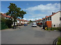
2
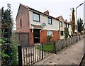
Nos.124-118 (evens) Botcherby Avenue
There is an Ordnance Survey benchmark Image on the side of the nearest house just through the wooden gate
Image: © Roger Templeman
Taken: 16 Oct 2021
0.13 miles
3
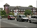
Premier Inn, Carlisle Central
Beside a busy A69, Warwick Road.
Image: © Richard Sutcliffe
Taken: 14 Jun 2019
0.13 miles
5
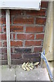
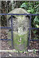
Benchmark on side of #124 Botcherby Avenue
Ordnance Survey cut mark benchmark described on the Bench Mark Database at http://www.bench-marks.org.uk/bm38290
Image: © Roger Templeman
Taken: 12 Jun 2011
0.13 miles
7
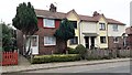
Nos. 65-71 (odds) Botcherby Avenue
There is an Ordnance Survey benchmark Image on the side of the left hand house at its front corner
Image: © Roger Templeman
Taken: 16 Oct 2021
0.14 miles
8
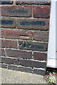
Benchmark on side of #65 Botcherby Avenue
Ordnance Survey cut mark benchmark described on the Bench Mark Database at http://www.bench-marks.org.uk/bm36199
Image: © Roger Templeman
Taken: 12 Jun 2011
0.14 miles
9
Benchmarked milestone on south side of Warwick Road
The milestone has had its mileage plates removed, originally indicating Carlisle 1 and Brampton 8. The Ordnance Survey cut mark benchmark visible on the right hand side of the stone is described on the Bench Mark Database at http://www.bench-marks.org.uk/bm38280
Image: © Roger Templeman
Taken: 12 Jun 2011
0.14 miles
10
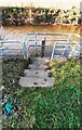
Platform of river monitoring station on east bank of River Petteril
There is an Environment Agency benchmark Image on the horizontal concrete platform at the bottom of the steps
Image: © Roger Templeman
Taken: 11 Nov 2023
0.15 miles