IMAGES TAKEN NEAR TO
Borland Avenue, CARLISLE, CA1 2TL
Introduction
This page details the photographs taken nearby to Borland Avenue, CA1 2TL by members of the Geograph project.
The Geograph project started in 2005 with the aim of publishing, organising and preserving representative images for every square kilometre of Great Britain, Ireland and the Isle of Man.

There are currently over 7.5m images from over14,400 individuals and you can help contribute to the project by visiting https://www.geograph.org.uk
Image Map
Images are licensed for reuse under creativecommons.org/licenses/by-sa/2.0
Notes
- Clicking on the map will re-center to the selected point.
- The higher the marker number, the further away the image location is from the centre of the postcode.
Image Listing (23 Images Found)
Images are licensed for reuse under creativecommons.org/licenses/by-sa/2.0
Image
Details
Distance
2
Nos. 25 and 27 Ennerdale Avenue
There is a Ordnance Survey benchmark Image on the side of the left hand house at its front corner
Image: © Roger Templeman
Taken: 16 Oct 2021
0.11 miles
3
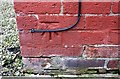
Benchmark on the side of #25 Ennerdale Avenue
Ordnance Survey cut mark benchmark described on the Bench Mark Database at http://www.bench-marks.org.uk/bm38289
Image: © Roger Templeman
Taken: 12 Jun 2011
0.11 miles
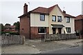
4
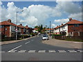
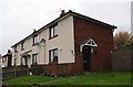
Borland Avenue houses
There is an OS benchmark Image on the side of the right hand house at its front corner
Image: © Luke Shaw
Taken: 16 Nov 2019
0.12 miles
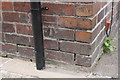
5
Benchmark on 99 Borland Avenue
Ordnance Survey cut mark benchmark described on the Bench Mark Database at www.bench-marks.org.uk/bm113310
Image: © Luke Shaw
Taken: 16 Nov 2019
0.12 miles
8
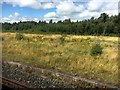
Durranhill Sidings
Viewed from a passing steam-hauled train on The Dalesman excursion to the Settle-Carlisle line and seemingly abandoned some time ago
Image: © Graham Hogg
Taken: 7 Aug 2017
0.17 miles
9
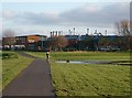
Dog enjoying a paddle in waterlogged Melbourne Park
The factory behind is Crown Bevcan (makers of beverage cans), formerly known as Metal Box.
Image: © Rose and Trev Clough
Taken: 16 Jan 2008
0.18 miles
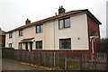
10
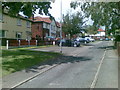
Houses on Merith Avenue
Ordnance Survey records indicate that a benchmark was cut on the near corner of the block in 1972. See www.bench-marks.org.uk/bm113309
Image: © Luke Shaw
Taken: 16 Nov 2019
0.18 miles